
فائل:Tilisunahütte Panorama.jpg
ایس وکھالے دا ناپ: ۸۰۰ × ۲۱۱ پکسلز۔ دوجے ریزولوشنز: ۳۲۰ × ۸۴ پکسلز | ۶۴۰ × ۱۶۹ پکسلز | ۱,۰۲۴ × ۲۷۰ پکسلز | ۱,۲۸۰ × ۳۳۷ پکسلز | ۶,۷۱۱ × ۱,۷۶۸ پکسلز ۔
اصل فائل (۶,۷۱۱ × ۱,۷۶۸ پکسلز, فائل حجم: ۸.۶۸ میگابائٹ, MIME type: image/jpeg)
| تفصیل |
Čeština: Panorama z pohoří Rätikon v Rakousko, nedaleko hranic se Švýcarskem. Vlevo chata Tilisunahütte Rakouského alpského spolku ležící ve výšce 2211 m n. m.
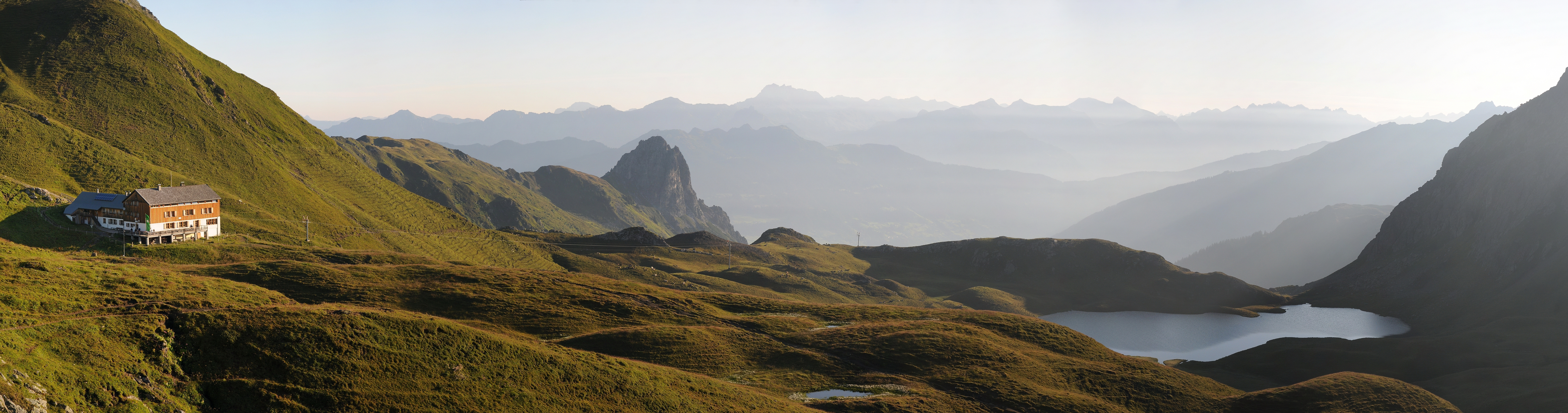
Deutsch: Panorama um 07:10 Uhr nach dem Sonnenaufgang über dem Tilisunasee. Links die Tilisunahütte. Sie ist eine Berghütte des Österreichischen Alpenvereins (OeAV), Sektion Vorarlberg, in der Region Montafon, Bundesland Vorarlberg / Österreich. Sie liegt südlich von Tschagguns auf einer Höhe von 2'211 m ü. M. nördlich der Sulzfluh, in aussichtsreicher Lage mit Blick ins Montafon. Der Berganstieg links führt auf das Tilisuna-Schwarzhorn 2.460m und in der Bildmitte die Tschaggunser Mittagsspitze.
English: Panoramic picture of Rätikon mountain range in Austria, near the border of Switzerland, with Austrian Alpine Club hut Tilisunahütte on the left. Hut is located south of village Tschagguns in elevation of 2,211 m.
Русский: Окрестности Чаггунс, Форарльберг, Австрия.
Italiano: Foto panoramica della catena del Rätikon in Austria vicino al confine svizzero. Sulla sinistra il rifugio Tilisunahütte dell'Österreichischer Alpenverein.
|
||
| تریخ | |||
| سروت | آپݨا کم | ||
| لکھاری | böhringer friedrich | ||
| اجازت (فائل نوں دوبارہ ورتنا) |
میں، اس کم دے کاپیرائٹ دا مالک، اس کم نوں اس لائسنس دے مطابق چھاپدا واں: ایس فائل نوں کریٹو کامنز Attribution 2.5 جنرک لائسنس دتا گیا.
|

| Camera location | | View this and other nearby images on: OpenStreetMap |
|---|
This Photo was taken by Böhringer Friedrich.
|
Feel free to use my photos, but please mention me as the author and if you want send me a message. or (rufre@lenz-nenning.at) |
| Annotations | This image is annotated: View the annotations at Commons |
Assessment
|

This image was selected as picture of the day on Wikimedia Commons for 1 August 2012. It was captioned as follows: English: Panoramic picture of Rätikon mountain range in Austria, near the border of Switzerland, with Austrian Alpine Club hut Tilisunahütte on the left. Other languages:
English: Panoramic picture of Rätikon mountain range in Austria, near the border of Switzerland, with Austrian Alpine Club hut Tilisunahütte on the left. Italiano: Foto panoramica della catena del Rätikon in Austria vicino al confine svizzero. Sulla sinistra il rifugio Tilisunahütte dell'Österreichischer Alpenverein. Magyar: A Rätikon-hegység panorámaképe Ausztriában, közel a svájci határhoz. Bal oldalon a Tilisunahütte alpesi menedékház. Nederlands: Panoramische foto van het bergmassief Rätikon in Oostenrijk nabij de grens met Zwitserland met links de Tilisunahütte van de Österreichischer Alpenverein. Português: Imagem panorâmica da cordilheira Rätikon, na Áustria, próximo à fronteira com a Suíça. Русский: Панорама хребта Ретикон в Австрии. Слева горная хижина Тилисуна, принадлежащая Австрийскому Горному Клубу ქართული: რეტიკონის ქედის პანორამა ავსტრიაში, შვეიცარიის საზღვრის სიახლოვეს. მარცხნივ ავსტრიული სამთო კლუბის ქოხი. 中文: 雷蒂孔山在奥地利的全景图,靠近与瑞士的边境,左边有一座奥地利阿尔卑斯山俱乐部的小屋。 |
This image has been assessed using the Quality image guidelines and is considered a Quality image.
|
فائل دی تریخ
فائل نو اس ویلے دی حالت وچ ویکھن واسطے تاریخ/ویلے تے کلک کرو۔
| تریخ تے ویلہ | نکی مورت | پاسے | ورتن والا | تیپّݨی کرو | |
|---|---|---|---|---|---|
| موجودہ | ۰۲:۱۱, ۳ اگست ۲۰۱۱ | ۶,۷۱۱ × ۱,۷۶۸ (۸.۶۸ میگابائٹ) | Böhringer | {{Information |Description= {{de|Panorama um 07:10 Uhr nach dem Sonnenaufgang über dem Tilisunasee. Links die Tilisunahütte. Sie ist eine Berghütte des Österreichischen Alpenvereins (OeAV), Sektion Vorarlberg, in der Region [[:d |
فائل دی ورتوں
اس فائل نال جڑیا کوئی صفحہ نئیں۔
فائل ویاپک ورتوں
ایہہ دوجے وکیاں ایس فائل نوں ورتدے نیں –
- be-tarask.wikipedia.org تے ورتوں
- bn.wikipedia.org تے ورتوں
- crh.wikipedia.org تے ورتوں
- cv.wikipedia.org تے ورتوں
- de.wikipedia.org تے ورتوں
- en.wikipedia.org تے ورتوں
- et.wikipedia.org تے ورتوں
- hu.wikipedia.org تے ورتوں
- it.wikipedia.org تے ورتوں
- ka.wikipedia.org تے ورتوں
- ko.wikipedia.org تے ورتوں
- krc.wikipedia.org تے ورتوں
- lbe.wikipedia.org تے ورتوں
- os.wikipedia.org تے ورتوں
- ru.wikipedia.org تے ورتوں
- ru.wikinews.org تے ورتوں
- sah.wikipedia.org تے ورتوں
- sr.wikipedia.org تے ورتوں
- uk.wikipedia.org تے ورتوں
- vi.wikipedia.org تے ورتوں
- xal.wikipedia.org تے ورتوں
- zh.wikipedia.org تے ورتوں