Jump to content

فائل:Washington, D.C. locator map.svg

Page contents not supported in other languages.
آزاد انسائیکلوپیڈیا، وکیپیڈیا توں

اصل فائل (ایس وی جی فائل، پکسل:۷۵۰ × ۵۵۰، فائل سائز: ۱۶۰ کلوبائٹ)

ایہ فائل Wikimedia Commons توں اے تے دوجیاں ویونتاں تے وی ورتی جاسکدی اے۔ گل بات اس دے فائل گل بات صفحہ تے تھلے دتی گئی۔

تفصیل
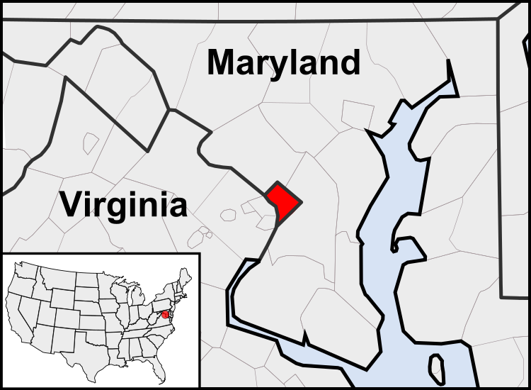
English: This is a map of the location of the District of Columbia showing the borders of states and counties around it.
تریخ (UTC)
سروت
لکھاری
دوجے ورژن

Derivative works of this file:  United States geographical collation.svg All the below are of the states (and DC) only.
Blank US map.svg Map of states
Labelled US map.svg Map with state labels
USA_blank.svg Image with Hawaii and Alaska in full size
Original blank map of USA and Canada, That image with labels
Original with Hawaii at the natural distance, That original map with labels

File:DC locator map with state names w usmap.png and File:DC locator map with state names.jpg


This is a retouched picture, which means that it has been digitally altered from its original version. Modifications: Cropping to area around District of Columbia. The original can be viewed here: Blank USA, w territories.svg. Modifications made by Patrickneil.

w:en:Creative Commons
کس دے ناں اکو جہا شئیر کرو۔
ایس فائل نوں کریٹو کامنز Attribution 2.5 پولینڈ لائسنس دتا گیا.
تہانوں کھلھ اے:
  • حصہ کرنا – کاپی، ونڈنا تے کم بھیجنا
  • فیر رلانا – کم نوں فٹ کرنا
تھلے دتیاں شرطاں نال:
  • کس دے ناں – تسیں لازمی ایس کم دے بناں والے بارے دسو جنج اونے آکھیا اے یا جنج لسنس چ آکھیا گیا ہے۔
  • اکو جہا شئیر کرو۔ – اگر تسیں بدلدے یا ایس کم تے بناندے تے بنن والے کم نوں اینج دے لسنس نال ای ونڈو گے۔

پہلا اپلوڈ دا ریکارڈ

This image is a derivative work of the following images:

  • File:USA_Counties.svg licensed with PD-USGov-DOC-Census
    • 2007-12-23T15:47:48Z Lokal Profil 555x352 (2124572 Bytes) Fixed state borders and fixed the two parts of Fulton County (Kentucky)
    • 2007-12-10T02:20:23Z Lokal Profil 555x352 (2136501 Bytes) Graphical and code cleanup
    • 2007-12-10T01:15:05Z Lokal Profil 792x612 (2135690 Bytes) First stab at a code cleanup
    • 2006-08-29T00:14:37Z Petr Dlouhý 792x612 (2844548 Bytes) Original file: [[:en:Image:USA CountiesSVG.zip]] This [[ZIP (file format)|ZIP]] file contains an [[SVG]] map of the [[United States]] showing the borders of states and counties in high detail. It was derived from [http://ww
  • File:Blank_USA,_w_territories.svg licensed with Cc-by-sa-3.0-migrated, GFDL
    • 2009-01-30T01:59:59Z Hoshie 959x593 (98189 Bytes) Reverted to version as of 23:58, 14 January 2009 - rv myself; DC can be seen clearly.
    • 2009-01-18T23:34:42Z Hoshie 959x593 (102341 Bytes) Put DC in an inset; fixed Tutuila (American Samoa)
    • 2009-01-14T23:58:05Z Lokal Profil 959x593 (98189 Bytes) Code cleanup and removed stroke from Guam and American Samoa
    • 2009-01-13T05:19:51Z Hoshie 959x593 (101361 Bytes) re did Guam and added American Samoa
    • 2007-12-02T16:08:45Z Lokal Profil 959x593 (88960 Bytes) {{Information |Description=A blank map of the United States including Puerto Rico, Guam, the United States Virgin Islands, and the Northern Mariana Islands. |Source=This version was made by [[:User:Lokal_Profil|Lokal_Profil]]

Uploaded with derivativeFX

Captions

Add a one-line explanation of what this file represents

Items portrayed in this file

چترن

copyrighted English

۱۲ اگست 2010

data size English

۱۶۳,۹۴۴ بائٹ

height English

۵۵۰ pixel

width English

۷۵۰ pixel

media type English

image/svg+xml

checksum English

f7e81873c67c8d3b8b0d46c9f5f5687a99abbfb4

فائل دی تریخ

فائل نو اس ویلے دی حالت وچ ویکھن واسطے تاریخ/ویلے تے کلک کرو۔

(سبھ توں نواں | سبھ توں پراݨا) ویکھو (زیادہ نواں ۱۰ | ) (۱۰ | ۲۰ | ۵۰ | ۱۰۰ | ۲۵۰ | ۵۰۰)
تریخ تے ویلہنکی مورتپاسےورتن والاتیپّݨی کرو
موجودہ۰۸:۲۳, ۲۳ جولائی ۲۰۱۱۰۸:۲۳, ۲۳ جولائی ۲۰۱۱ ویلے دے ورژن ساتھ انگوٹھاکار روپ۷۵۰ × ۵۵۰ (۱۶۰ کلوبائٹ)PatrickneilReverted to version as of 03:04, 23 July 2011
۰۸:۲۱, ۲۳ جولائی ۲۰۱۱۰۸:۲۱, ۲۳ جولائی ۲۰۱۱ ویلے دے ورژن ساتھ انگوٹھاکار روپ۷۵۰ × ۵۵۰ (۱۶۱ کلوبائٹ)PatrickneilReverted to version as of 03:14, 23 July 2011
۰۸:۲۰, ۲۳ جولائی ۲۰۱۱۰۸:۲۰, ۲۳ جولائی ۲۰۱۱ ویلے دے ورژن ساتھ انگوٹھاکار روپ۷۵۰ × ۵۵۰ (۱۶۱ کلوبائٹ)Patrickneilframe
۰۸:۱۴, ۲۳ جولائی ۲۰۱۱۰۸:۱۴, ۲۳ جولائی ۲۰۱۱ ویلے دے ورژن ساتھ انگوٹھاکار روپ۷۵۰ × ۵۵۰ (۱۶۱ کلوبائٹ)Patrickneilthicker frame
۰۸:۰۴, ۲۳ جولائی ۲۰۱۱۰۸:۰۴, ۲۳ جولائی ۲۰۱۱ ویلے دے ورژن ساتھ انگوٹھاکار روپ۷۵۰ × ۵۵۰ (۱۶۰ کلوبائٹ)Patrickneilstraightening Maryland and Delaware borders
۰۷:۰۹, ۱۵ اگست ۲۰۱۰۰۷:۰۹, ۱۵ اگست ۲۰۱۰ ویلے دے ورژن ساتھ انگوٹھاکار روپ۷۵۰ × ۵۵۰ (۲۰۲ کلوبائٹ)PatrickneilDelaware River again
۰۶:۵۱, ۱۵ اگست ۲۰۱۰۰۶:۵۱, ۱۵ اگست ۲۰۱۰ ویلے دے ورژن ساتھ انگوٹھاکار روپ۷۵۰ × ۵۵۰ (۲۷۴ کلوبائٹ)PatrickneilDelaware River border
۰۶:۴۲, ۱۵ اگست ۲۰۱۰۰۶:۴۲, ۱۵ اگست ۲۰۱۰ ویلے دے ورژن ساتھ انگوٹھاکار روپ۷۵۰ × ۵۵۰ (۲۷۳ کلوبائٹ)Patrickneilforgot border on Smith Island
۰۶:۳۴, ۱۵ اگست ۲۰۱۰۰۶:۳۴, ۱۵ اگست ۲۰۱۰ ویلے دے ورژن ساتھ انگوٹھاکار روپ۷۵۰ × ۵۵۰ (۲۷۳ کلوبائٹ)Patrickneilcounty borders below state
۰۶:۳۲, ۱۵ اگست ۲۰۱۰۰۶:۳۲, ۱۵ اگست ۲۰۱۰ ویلے دے ورژن ساتھ انگوٹھاکار روپ۷۵۰ × ۵۵۰ (۲۷۴ کلوبائٹ)Patrickneilchanges by request
(سبھ توں نواں | سبھ توں پراݨا) ویکھو (زیادہ نواں ۱۰ | ) (۱۰ | ۲۰ | ۵۰ | ۱۰۰ | ۲۵۰ | ۵۰۰)

تھلے دتے گئے 1 صفحے اس فائل نال جُڑدے نیں

فائل ویاپک ورتوں

ایہہ دوجے وکیاں ایس فائل نوں ورتدے نیں –

ایس فائل دا ویکھو ہور جگت ورتن .