
فائل:Aerial-View-Minamitori-Island-1987.jpg

ایس وکھالے دا ناپ: ۸۰۰ × ۵۰۷ پکسلز۔ دوجے ریزولوشنز: ۳۲۰ × ۲۰۳ پکسلز | ۶۴۰ × ۴۰۵ پکسلز | ۱,۰۲۴ × ۶۴۹ پکسلز | ۱,۲۸۰ × ۸۱۱ پکسلز | ۲,۸۲۴ × ۱,۷۸۹ پکسلز ۔
اصل فائل (۲,۸۲۴ × ۱,۷۸۹ پکسلز, فائل حجم: ۱.۰۹ میگابائٹ, MIME type: image/jpeg)
خلاصہ
| تفصیل |
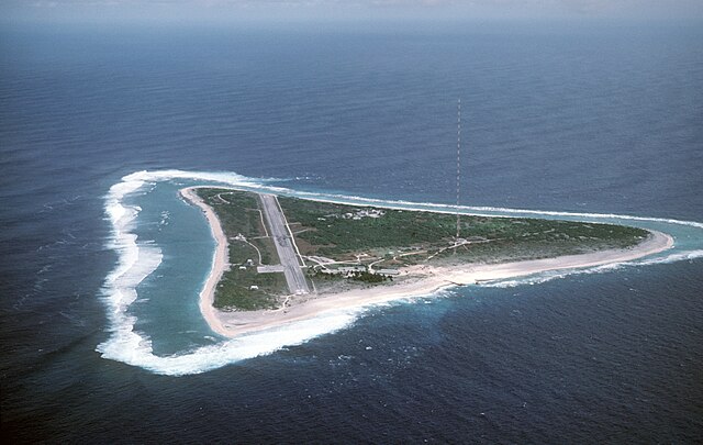
English: Aerial view of Minamitori Island (Minami-Torishima), Japan. There is a runway which supported the US Coast Guard station located there prior to 1993. Minamitori Island is the easternmost island of the Japanese archipelago.
Deutsch: Luftaufnahme der Minamitori Insel (Minami-Torishima), Japan.
日本語: 南鳥島の空中写真。 |
|||
| تریخ | ||||
| سروت |
|
|||
| لکھاری | Chief Master Sergeant Don Sutherland, U.S. Air Force |
لائسنس –
This image is a work of a U.S. military or Department of Defense employee, taken or made as part of that person's official duties. As a work of the U.S. federal government, the image is in the public domain in the United States.
|
 |
فائل دی تریخ
فائل نو اس ویلے دی حالت وچ ویکھن واسطے تاریخ/ویلے تے کلک کرو۔
| تریخ تے ویلہ | نکی مورت | پاسے | ورتن والا | تیپّݨی کرو | |
|---|---|---|---|---|---|
| موجودہ | ۰۶:۳۸, ۱۸ جنوری ۲۰۰۷ | | ۲,۸۲۴ × ۱,۷۸۹ (۱.۰۹ میگابائٹ) | Balcer~commonswiki | ID: DFST8708298 Service Depicted: Coalition or Allied Forces Aerial view of Marcus Island and the runway which supports the US Coast Guard station located there. Marcus Island is the southernmost island in the Japanese chain. Camera Operator: CMSGT |
فائل دی ورتوں
تھلے دتے گئے 1 صفحے اس فائل نال جُڑدے نیں
فائل ویاپک ورتوں
ایہہ دوجے وکیاں ایس فائل نوں ورتدے نیں –
- ar.wikipedia.org تے ورتوں
- ast.wikipedia.org تے ورتوں
- az.wikipedia.org تے ورتوں
- be.wikipedia.org تے ورتوں
- ca.wikipedia.org تے ورتوں
- ceb.wikipedia.org تے ورتوں
- cs.wikipedia.org تے ورتوں
- de.wikipedia.org تے ورتوں
- el.wikipedia.org تے ورتوں
- en.wikipedia.org تے ورتوں
- es.wikipedia.org تے ورتوں
- et.wikipedia.org تے ورتوں
- eu.wikipedia.org تے ورتوں
- fa.wikipedia.org تے ورتوں
- fi.wikipedia.org تے ورتوں
- frr.wikipedia.org تے ورتوں
- fr.wikipedia.org تے ورتوں
- fr.wiktionary.org تے ورتوں
- gl.wikipedia.org تے ورتوں
- hy.wikipedia.org تے ورتوں
- it.wikipedia.org تے ورتوں
- ja.wikipedia.org تے ورتوں
ایس فائل دا ویکھو ہور جگت ورتن .