
فائل:BC-relief.png

ایس وکھالے دا ناپ: ۵۸۵ × ۵۹۹ پکسلز۔ دوجے ریزولوشنز: ۲۳۴ × ۲۴۰ پکسلز | ۴۶۹ × ۴۸۰ پکسلز | ۶۵۹ × ۶۷۵ پکسلز ۔
اصل فائل (۶۵۹ × ۶۷۵ پکسلز, فائل حجم: ۶۰۵ کلوبائٹ, MIME type: image/png)
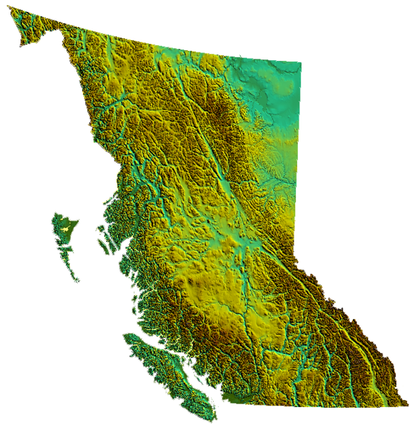
خلاصہ
| تفصیل |
relief of British Columbia, Canada produced from USGS data |
| تریخ | ۳۱ مارچ ۲۰۰۶ (original upload date) |
| سروت | No machine-readable source provided. Own work assumed (based on copyright claims). |
| لکھاری | No machine-readable author provided. Qyd assumed (based on copyright claims). |
لائسنس –
| میں، اس کم دے کاپیرائٹ دا مالک، اس کم نوں لوکاں واسطے دیندا واں۔ اے سارے جگ واسطے لاگو اے۔ کج ملکاں چ قانونی طور تے اے ممکن نئیں اے؛ اگر انج ای اے ے: میں ہر کسے نوں اس کم نوں کسے وی مقصد واسطے ورتن دا بغیر کسے شرط دے حق دیندا واں، اگر اوہ قانون دے خلاف نا ہوۓ۔ |
فائل دی تریخ
فائل نو اس ویلے دی حالت وچ ویکھن واسطے تاریخ/ویلے تے کلک کرو۔
| تریخ تے ویلہ | نکی مورت | پاسے | ورتن والا | تیپّݨی کرو | |
|---|---|---|---|---|---|
| موجودہ | ۰۶:۳۹, ۴ نومبر ۲۰۰۶ | | ۶۵۹ × ۶۷۵ (۶۰۵ کلوبائٹ) | Qyd | transparent background |
| ۰۷:۰۱, ۳۱ مارچ ۲۰۰۶ |  | ۶۵۹ × ۶۷۵ (۵۳۶ کلوبائٹ) | Qyd | relief of British Columbia, Canada |
فائل دی ورتوں
تھلے دتے گئے 1 صفحے اس فائل نال جُڑدے نیں
فائل ویاپک ورتوں
ایہہ دوجے وکیاں ایس فائل نوں ورتدے نیں –
- as.wikipedia.org تے ورتوں
- bcl.wikipedia.org تے ورتوں
- de.wikipedia.org تے ورتوں
- en.wikipedia.org تے ورتوں
- Coombs, British Columbia
- Della Falls
- Regional District of Kootenay Boundary
- Eagle Pass (British Columbia)
- Cameron Bar Indian Reserve No. 13
- Mount McGuire (Alberta)
- Mount King Edward
- Flores Island (British Columbia)
- Ball Range
- 105 Mile Post Indian Reserve No. 2
- Madeira Park
- Queen Charlotte Sound (Canada)
- Nootka Island
- Beatrice Peak
- Isabelle Peak
- Duke Point, British Columbia
- Haiduk Peak
- Kinney Lake
- Spanish Bonk
- Mount Cornwell (Canada)
- Laidlaw, British Columbia
- Pearse Island
- Portland Canal
- President Range
- Regional District of Central Kootenay
- Regional District of Bulkley-Nechako
- Cowichan Valley
- Saltair, British Columbia
- Mount Macdonald
- Basque, British Columbia
- Oweekeno
- Clark Range (Canada)
- Kaien Island
- Mount Field (British Columbia)
- Beaverfoot Range
- Halfmoon Bay, British Columbia
- Atlin Lake
- Williston Lake
- Columbia Valley
- Lake Revelstoke
- Moyie Lake
- Wood Lake (British Columbia)
- Baynes Sound
- Kokanee Lake
- Kinbasket Lake
- Wasa Lake
- Wilmer, British Columbia
ایس فائل دا ویکھو ہور جگت ورتن .