
فائل:Bingöl districts.png

ایس وکھالے دا ناپ: ۷۷۶ × ۶۰۰ پکسلز۔ دوجے ریزولوشنز: ۳۱۱ × ۲۴۰ پکسلز | ۶۲۱ × ۴۸۰ پکسلز | ۹۹۴ × ۷۶۸ پکسلز | ۱,۰۵۶ × ۸۱۶ پکسلز ۔
اصل فائل (۱,۰۵۶ × ۸۱۶ پکسلز, فائل حجم: ۲۴ کلوبائٹ, MIME type: image/png)
خلاصہ
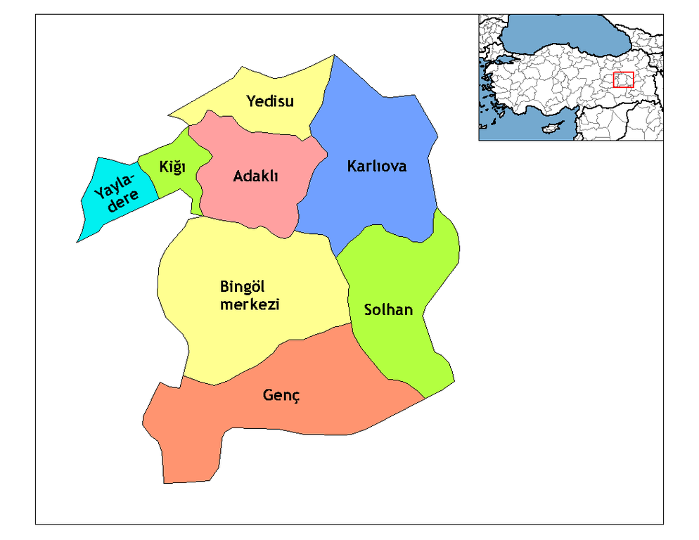
| تفصیل | Map of the districts of Bingöl province in Turkey. Created by Rarelibra 18:56, 1 December 2006 (UTC) for public domain use, using MapInfo Professional v8.5 and various mapping resources. Edited by One Homo Sapiens Corrected text where İ,Ş,ı,ğ,or ş occurs in name. Source: [statoids-com]. Increased font size and enhanced color differences among adjacent districts. |
| تریخ | ۳۱ مارچ ۲۰۰۷ (original upload date) |
| سروت | No machine-readable source provided. Own work assumed (based on copyright claims). |
| لکھاری | No machine-readable author provided. Denizz~commonswiki assumed (based on copyright claims). |
لائسنس –
| میں، اس کم دے کاپیرائٹ دا مالک، اس کم نوں لوکاں واسطے دیندا واں۔ اے سارے جگ واسطے لاگو اے۔ کج ملکاں چ قانونی طور تے اے ممکن نئیں اے؛ اگر انج ای اے ے: میں ہر کسے نوں اس کم نوں کسے وی مقصد واسطے ورتن دا بغیر کسے شرط دے حق دیندا واں، اگر اوہ قانون دے خلاف نا ہوۓ۔ |
فائل دی تریخ
فائل نو اس ویلے دی حالت وچ ویکھن واسطے تاریخ/ویلے تے کلک کرو۔
| تریخ تے ویلہ | نکی مورت | پاسے | ورتن والا | تیپّݨی کرو | |
|---|---|---|---|---|---|
| موجودہ | ۰۲:۱۰, ۲۹ دسمبر ۲۰۰۸ | | ۱,۰۵۶ × ۸۱۶ (۲۴ کلوبائٹ) | One Homo Sapiens | Corrected text where İ,Ş,ı,ğ,or ş occurs in name. Source: [statoids-com]. Increased font size and enhanced color differences among adjacent districts. |
| ۱۱:۵۰, ۳۱ مارچ ۲۰۰۷ |  | ۱,۰۵۶ × ۸۱۶ (۲۵ کلوبائٹ) | Denizz~commonswiki | == Summary == Map of the districts of Bingol province in Turkey. Created by Rarelibra 18:56, 1 December 2006 (UTC) for public domain use, using MapInfo Professional v8.5 and various mapping resources. == Licensing == {{PD-self}} <!-- |
فائل دی ورتوں
تھلے دتے گئے 9 صفحے اس فائل نال جُڑدے نیں
فائل ویاپک ورتوں
ایہہ دوجے وکیاں ایس فائل نوں ورتدے نیں –
- ast.wikipedia.org تے ورتوں
- ca.wikipedia.org تے ورتوں
- cs.wikipedia.org تے ورتوں
- de.wikipedia.org تے ورتوں
- Yayladere
- Kiğı
- Yedisu
- Vorlage:Navigationsleiste Landkreise der Provinz Bingöl
- Adaklı
- Bingöl
- Genç (Bingöl)
- Karlıova
- Solhan (Türkei)
- Çatalkaya
- Dallıca
- Eskikavak
- Güneyağıl
- Kutluca
- Demirdöş
- Yorgançayır
- Yazgünü
- Açıkgüney
- Ağaçöven
- Alınyazı
- Aşağıserinyer
- Aşağıyağmurlu
- Aydınlar (Yayladere)
- Batıayaz
- Çalıkağıl
- Çayağzı
- Dalbasan
- Doğucak
- Gökçedal
- Günlük
- Haktanır
- Kalkanlı
- Kırköy
- Korlu
- Vorlage:Navigationsleiste Ortschaften im Landkreis Yayladere
- Sarıtosun
- Sürmelikoç (Yayladere)
- Yavuztaş
- Yaylabağ
- Zeynelli
- Vorlage:Navigationsleiste Ortschaften im Landkreis Kiğı
- Baklalı
- Bilekkaya
- Güneşlik
- Çiçektepe
- Darköprü
- Demirkanat
ایس فائل دا ویکھو ہور جگت ورتن .