
فائل:Czech Rep. - Bohemia, Moravia and Silesia III (en).png
ایس وکھالے دا ناپ: ۸۰۰ × ۴۵۴ پکسلز۔ دوجے ریزولوشنز: ۳۲۰ × ۱۸۲ پکسلز | ۶۴۰ × ۳۶۴ پکسلز | ۱,۰۲۴ × ۵۸۲ پکسلز | ۱,۲۸۰ × ۷۲۷ پکسلز | ۲,۵۶۰ × ۱,۴۵۴ پکسلز | ۳,۸۵۲ × ۲,۱۸۸ پکسلز ۔
اصل فائل (۳,۸۵۲ × ۲,۱۸۸ پکسلز, فائل حجم: ۱.۱۱ میگابائٹ, MIME type: image/png)
.png)

|
This historical map image could be re-created using vector graphics as an SVG file. This has several advantages; see Commons:Media for cleanup for more information. If an SVG form of this image is available, please upload it and afterwards replace this template with
{{vector version available|new image name}}.
It is recommended to name the SVG file “Czech Rep. - Bohemia, Moravia and Silesia III (en).svg”—then the template Vector version available (or Vva) does not need the new image name parameter. |
| تفصیل |
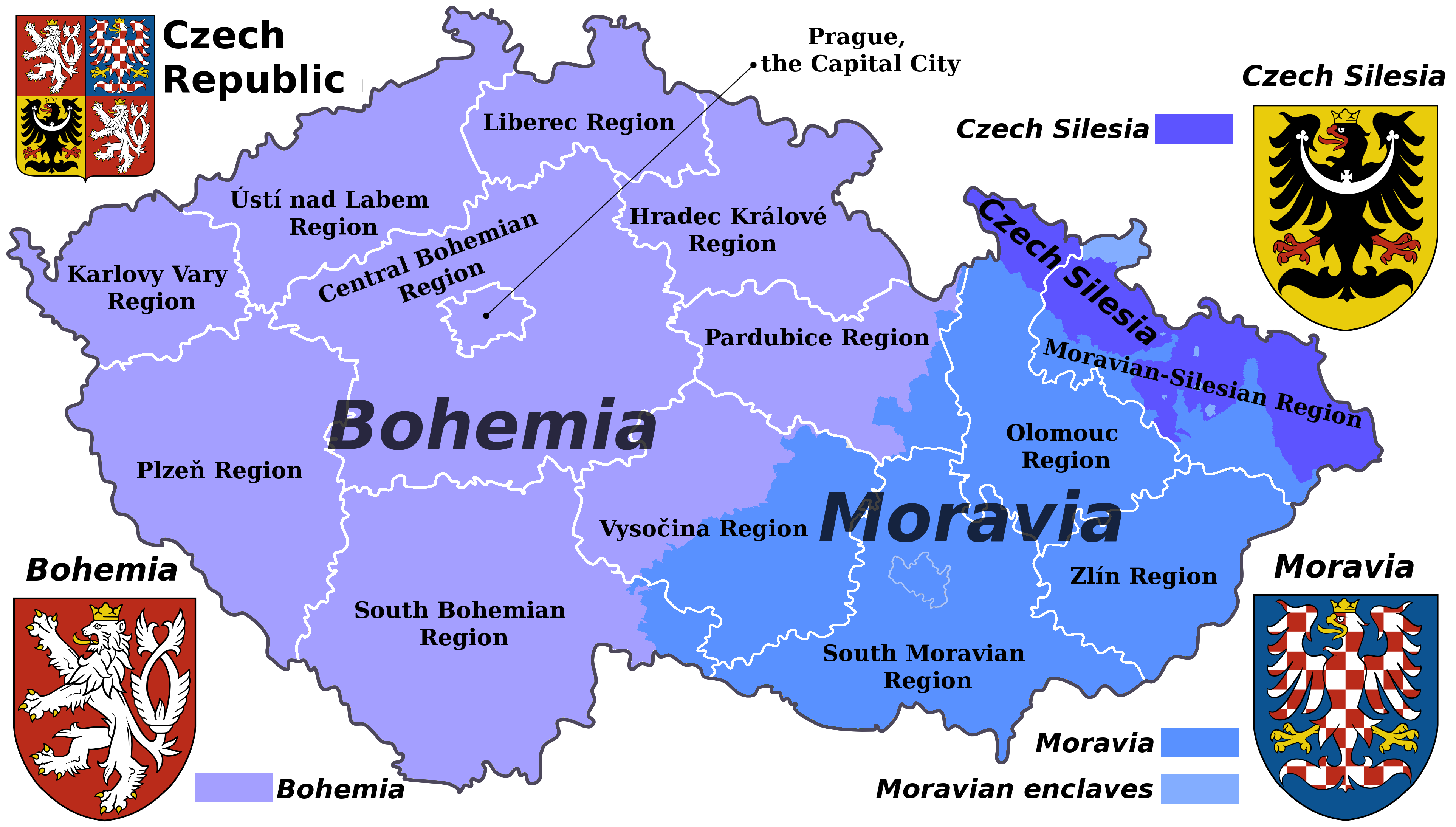
English: Map of the Czech republic showing the borders of its historical lands and the borders of the current administrative regions (kraje).
Čeština: Mapa České republiky s vyznačenými hranicemi krajů a historických zemí. |
| تریخ | (UTC) |
| سروت | |
| لکھاری |
|
| This is a retouched picture, which means that it has been digitally altered from its original version. Modifications: Translated to English. The original can be viewed here: Czech Rep. - Bohemia, Moravia and Silesia III.png:
|
میں، اس کم دے کاپیرائٹ دا مالک، اس کم نوں اس لائسنس دے مطابق چھاپدا واں:
ایس فائل نوں کریٹو کامنز Attribution 2.5 پولینڈ لائسنس دتا گیا.
- تہانوں کھلھ اے:
- حصہ کرنا – کاپی، ونڈنا تے کم بھیجنا
- فیر رلانا – کم نوں فٹ کرنا
- تھلے دتیاں شرطاں نال:
- کس دے ناں – تسیں لازمی ایس کم دے بناں والے بارے دسو جنج اونے آکھیا اے یا جنج لسنس چ آکھیا گیا ہے۔
- اکو جہا شئیر کرو۔ – اگر تسیں بدلدے یا ایس کم تے بناندے تے بنن والے کم نوں اینج دے لسنس نال ای ونڈو گے۔
پہلا اپلوڈ دا ریکارڈ
This image is a derivative work of the following images:
- File:Czech_Rep._-_Bohemia,_Moravia_and_Silesia_III.png licensed with Cc-by-sa-3.0
- 2011-08-07T15:52:18Z Millenium187 3852x2188 (1393382 Bytes) {{Information |Description={{cs|Moderní verze historického znaku Moravy.}} {{cs| Moderní verze historického znaku Slezska.}}{{pl| Współczesna wersja herbu Czeskiego Śląska.}} |Source=*[[:File:Czech_Rep._-_Bohemia,_Mor
Uploaded with derivativeFX
فائل دی تریخ
فائل نو اس ویلے دی حالت وچ ویکھن واسطے تاریخ/ویلے تے کلک کرو۔
| تریخ تے ویلہ | نکی مورت | پاسے | ورتن والا | تیپّݨی کرو | |
|---|---|---|---|---|---|
| موجودہ | ۱۹:۱۲, ۱۹ مارچ ۲۰۲۳ | | ۳,۸۵۲ × ۲,۱۸۸ (۱.۱۱ میگابائٹ) | Moodylo333 | "Enclave" means: territory surrounded on '''all''' sides by the other territory |
| ۰۹:۲۲, ۲۹ ستمبر ۲۰۱۱ |  | ۳,۸۵۲ × ۲,۱۸۸ (۱.۱۱ میگابائٹ) | Millenium187 | more pleasant colours | |
| ۰۰:۳۸, ۸ اگست ۲۰۱۱ |  | ۳,۸۵۲ × ۲,۱۸۸ (۱.۳۳ میگابائٹ) | Millenium187 | {{Information |Description={{cs|Moderní verze historického znaku Moravy.}} {{cs| Moderní verze historického znaku Slezska.}}{{pl| Współczesna wersja herbu Czeskiego Śląska.}} |Source=*File:Czech_Rep._-_Bohemia,_Moravia_and_Silesia_III.png |D |
فائل دی ورتوں
اس فائل نال جڑیا کوئی صفحہ نئیں۔
فائل ویاپک ورتوں
ایہہ دوجے وکیاں ایس فائل نوں ورتدے نیں –
- az.wikipedia.org تے ورتوں
- en.wikipedia.org تے ورتوں
- pt.wikipedia.org تے ورتوں
- sq.wikipedia.org تے ورتوں
- uk.wikipedia.org تے ورتوں
- vi.wikipedia.org تے ورتوں
.png)