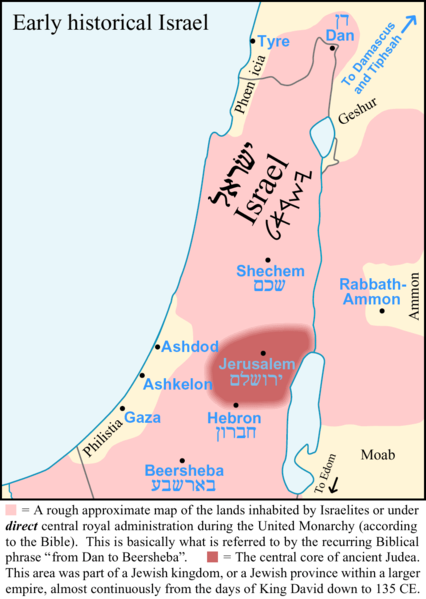
فائل:Early-Historical-Israel-Dan-Beersheba-Judea.png
Appearance

ایس وکھالے دا ناپ: ۴۲۶ × ۵۹۹ پکسلز۔ دوجے ریزولوشنز: ۱۷۰ × ۲۴۰ پکسلز | ۳۴۱ × ۴۸۰ پکسلز | ۸۶۰ × ۱,۲۱۰ پکسلز ۔
اصل فائل (۸۶۰ × ۱,۲۱۰ پکسلز, فائل حجم: ۵۸ کلوبائٹ, MIME type: image/png)
فائل دی تریخ
فائل نو اس ویلے دی حالت وچ ویکھن واسطے تاریخ/ویلے تے کلک کرو۔
| تریخ تے ویلہ | نکی مورت | پاسے | ورتن والا | تیپّݨی کرو | |
|---|---|---|---|---|---|
| موجودہ | ۱۳:۲۳, ۸ اکتوبر ۲۰۰۷ |  | ۸۶۰ × ۱,۲۱۰ (۵۸ کلوبائٹ) | AnonMoos | Reverted to version as of 10:47, 25 March 2006 -- Quasipalm, upload your own image under a different name, don't overwrite this one to impose your personal agenda |
| ۰۵:۵۷, ۸ اکتوبر ۲۰۰۷ |  | ۸۶۰ × ۱,۰۱۱ (۴۱ کلوبائٹ) | Quasipalm | '''eo:''' La bildo estas kopiita de wikipedia:en. La originala priskribo estas: == Summary == In this graphic about early historical Israel, the pink area is a rough approximate map of the near-maximum boundaries of the lands that were inhabited by Israe | |
| ۱۵:۴۷, ۲۵ مارچ ۲۰۰۶ |  | ۸۶۰ × ۱,۲۱۰ (۵۸ کلوبائٹ) | Maksim | La bildo estas kopiita de wikipedia:en. La originala priskribo estas: == Summary == In this graphic about early historical Israel, the pink area is a rough approximate map of the near-maximum boundaries of the lands that were inhabited by Israelites or |
فائل دی ورتوں
اس فائل نال جڑیا کوئی صفحہ نئیں۔
فائل ویاپک ورتوں
ایہہ دوجے وکیاں ایس فائل نوں ورتدے نیں –
- ar.wikipedia.org تے ورتوں
- arz.wikipedia.org تے ورتوں
- ca.wikipedia.org تے ورتوں
- en.wikipedia.org تے ورتوں
- fr.wikipedia.org تے ورتوں
- id.wikipedia.org تے ورتوں
- ka.wikipedia.org تے ورتوں
- ko.wikipedia.org تے ورتوں
- nl.wikipedia.org تے ورتوں
- pl.wikipedia.org تے ورتوں
- sq.wikipedia.org تے ورتوں
- th.wikipedia.org تے ورتوں
- tr.wikipedia.org تے ورتوں
- uk.wikipedia.org تے ورتوں
- vi.wikipedia.org تے ورتوں
- www.wikidata.org تے ورتوں

