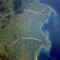
فائل:Godavari satellite view.jpg

ایس وکھالے دا ناپ: ۶۰۰ × ۶۰۰ پکسلز۔ دوجے ریزولوشنز: ۲۴۰ × ۲۴۰ پکسلز | ۴۸۰ × ۴۸۰ پکسلز | ۷۶۸ × ۷۶۸ پکسلز | ۱,۰۲۴ × ۱,۰۲۴ پکسلز | ۲,۰۴۸ × ۲,۰۴۸ پکسلز | ۵,۲۴۸ × ۵,۲۴۸ پکسلز ۔
اصل فائل (۵,۲۴۸ × ۵,۲۴۸ پکسلز, فائل حجم: ۸.۰۵ میگابائٹ, MIME type: image/jpeg)
فائل دی تریخ
فائل نو اس ویلے دی حالت وچ ویکھن واسطے تاریخ/ویلے تے کلک کرو۔
| تریخ تے ویلہ | نکی مورت | پاسے | ورتن والا | تیپّݨی کرو | |
|---|---|---|---|---|---|
| موجودہ | ۰۰:۲۷, ۵ مارچ ۲۰۱۸ |  | ۵,۲۴۸ × ۵,۲۴۸ (۸.۰۵ میگابائٹ) | Ras67 | levels adjusted |
| ۰۰:۲۴, ۵ مارچ ۲۰۱۸ |  | ۵,۲۴۸ × ۵,۲۴۸ (۸.۲۸ میگابائٹ) | Ras67 | high resolution | |
| ۰۴:۱۱, ۲۲ اکتوبر ۲۰۰۸ |  | ۶۴۰ × ۶۴۰ (۱۲۸ کلوبائٹ) | File Upload Bot (Magnus Manske) | {{BotMoveToCommons|fr.wikipedia}} {{Information |Description={{fr|les deltas de la Godâvarî et de la Krishnâ STS034-077-029 Godavari and Krishna River Deltas, India October 1989 The mouths of the Godavari River (east) and the Krishna River (wes |
فائل دی ورتوں
تھلے دتے گئے 1 صفحے اس فائل نال جُڑدے نیں
فائل ویاپک ورتوں
ایہہ دوجے وکیاں ایس فائل نوں ورتدے نیں –
- af.wikipedia.org تے ورتوں
- ar.wikipedia.org تے ورتوں
- arz.wikipedia.org تے ورتوں
- ast.wikipedia.org تے ورتوں
- az.wikipedia.org تے ورتوں
- bh.wikipedia.org تے ورتوں
- br.wikipedia.org تے ورتوں
- ca.wikipedia.org تے ورتوں
- ce.wikipedia.org تے ورتوں
- cy.wikipedia.org تے ورتوں
- de.wikivoyage.org تے ورتوں
- el.wikipedia.org تے ورتوں
- en.wikipedia.org تے ورتوں
- en.wiktionary.org تے ورتوں
- eo.wikipedia.org تے ورتوں
- es.wikipedia.org تے ورتوں
- eu.wikipedia.org تے ورتوں
- fi.wikipedia.org تے ورتوں
- fr.wikivoyage.org تے ورتوں
- ga.wikipedia.org تے ورتوں
- gl.wikipedia.org تے ورتوں
- ha.wikipedia.org تے ورتوں
- he.wikipedia.org تے ورتوں
- hy.wikipedia.org تے ورتوں
- id.wikipedia.org تے ورتوں
- it.wikipedia.org تے ورتوں
- ka.wikipedia.org تے ورتوں
- mr.wikipedia.org تے ورتوں
- ne.wikipedia.org تے ورتوں
- new.wikipedia.org تے ورتوں
- nn.wikipedia.org تے ورتوں
- no.wikipedia.org تے ورتوں
- os.wikipedia.org تے ورتوں
- pa.wikipedia.org تے ورتوں
- pl.wikipedia.org تے ورتوں
- ps.wikipedia.org تے ورتوں
- pt.wikipedia.org تے ورتوں
- ru.wikipedia.org تے ورتوں
- sa.wikipedia.org تے ورتوں
- sl.wikipedia.org تے ورتوں
ایس فائل دا ویکھو ہور جگت ورتن .


