
فائل:Map of the partition of the Kingdom of Poland and the Grand Duchy of Lithuania from 1799.jpg

ایس وکھالے دا ناپ: ۶۶۹ × ۶۰۰ پکسلز۔ دوجے ریزولوشنز: ۲۶۸ × ۲۴۰ پکسلز | ۵۳۵ × ۴۸۰ پکسلز | ۸۵۶ × ۷۶۸ پکسلز | ۱,۱۴۲ × ۱,۰۲۴ پکسلز | ۲,۲۸۴ × ۲,۰۴۸ پکسلز | ۶,۳۳۰ × ۵,۶۷۷ پکسلز ۔
اصل فائل (۶,۳۳۰ × ۵,۶۷۷ پکسلز, فائل حجم: ۶.۸۳ میگابائٹ, MIME type: image/jpeg)
خلاصہ
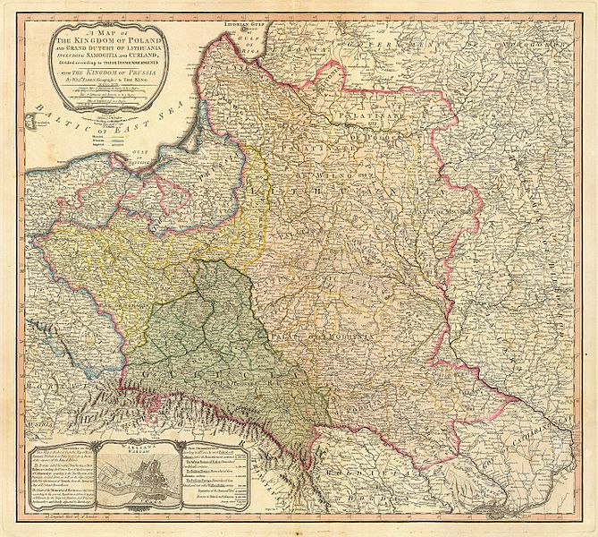
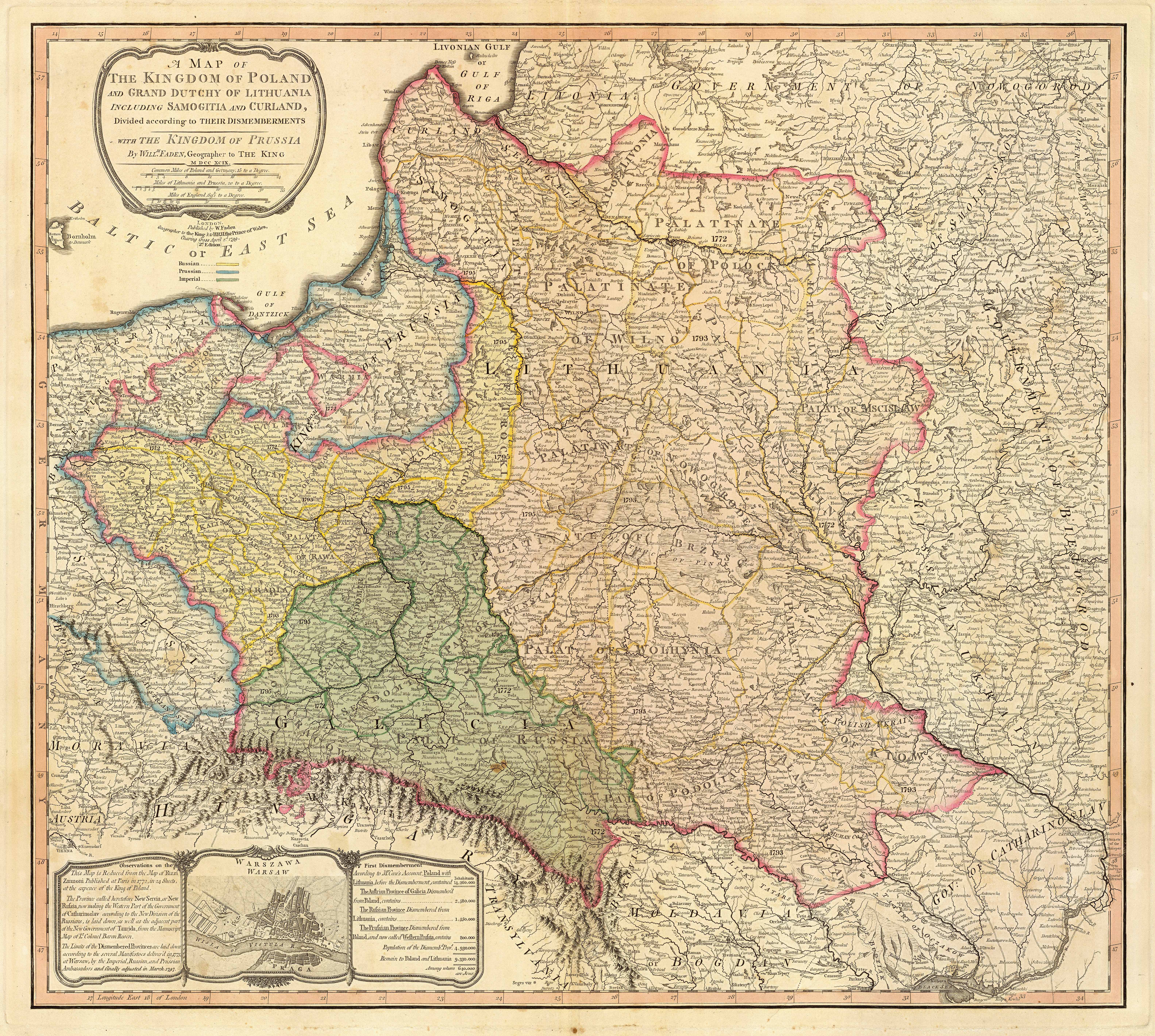
| تفصیل | Title: "A map of the Kingdom of Poland and the Grand Duchy of Lithuania including Samogitia and Curland divided according to their dismemberments with the Kingdom of Prussia". A map from 1799 showing how the Polish-Lithuanian Commonwealth was partitioned in 1765-1795 between Prussia, Austria, and Russia. This is an extremely detailed map which lists all the cities and small towns and labels the regions according to their English names. The boundaries former Polish-Lithuanian Commonwealth colored light red. The areas taken by Prussia are colored yellow, those taken by Austria colored green, and those taken by Russia are colored beige. Prussia itself is bordered in blue. Eastern Pomerania and Warmia are shown as part of Prussia but bordered in red as well. | ||||||||||||||||||||||
| تریخ | |||||||||||||||||||||||
| سروت | http://www.belarusguide.com/images/maps/Kokosha/POlonia&Lituania-1799.jpg | ||||||||||||||||||||||
| لکھاری |
|
||||||||||||||||||||||
لائسنس –
|
This work is in the public domain in its country of origin and other countries and areas where the copyright term is the author's life plus 100 years or fewer. | |
| ایہ فائل دے بارے چ دس اے جے اے کاپی حف دیاں روکاں توں کھلی اے تے نالدے رلدے حقاں توں وی۔ | |
فائل دی تریخ
فائل نو اس ویلے دی حالت وچ ویکھن واسطے تاریخ/ویلے تے کلک کرو۔
| تریخ تے ویلہ | نکی مورت | پاسے | ورتن والا | تیپّݨی کرو | |
|---|---|---|---|---|---|
| موجودہ | ۱۰:۰۴, ۲۳ ستمبر ۲۰۰۷ | | ۶,۳۳۰ × ۵,۶۷۷ (۶.۸۳ میگابائٹ) | Archaeogenetics | {{Information |Description=Title: "A map of the Kingdom of Poland and the Grand Duchy of Lithuania including Samogitia and Curland divided according to their dismemberments with the Kingdom of Prussia". A map from 1799 showing how the Polish-Lithuanian Co |
فائل دی ورتوں
تھلے دتے گئے 1 صفحے اس فائل نال جُڑدے نیں
فائل ویاپک ورتوں
ایہہ دوجے وکیاں ایس فائل نوں ورتدے نیں –
- en.wikipedia.org تے ورتوں
- et.wikipedia.org تے ورتوں
- lt.wikipedia.org تے ورتوں
- lt.wikibooks.org تے ورتوں
- th.wikipedia.org تے ورتوں
- uk.wikipedia.org تے ورتوں
- ur.wikipedia.org تے ورتوں
- zh.wikipedia.org تے ورتوں