
فائل:17th century Spanish routes to Petén flat.gif

ایس وکھالے دا ناپ: ۴۹۲ × ۶۰۰ پکسلز۔ دوجے ریزولوشنز: ۱۹۷ × ۲۴۰ پکسلز | ۳۹۴ × ۴۸۰ پکسلز | ۶۳۰ × ۷۶۸ پکسلز | ۱,۱۵۲ × ۱,۴۰۴ پکسلز ۔
اصل فائل (۱,۱۵۲ × ۱,۴۰۴ پکسلز, فائل حجم: ۵۱۶ کلوبائٹ, MIME type: image/gif)
خلاصہ
| تفصیل |
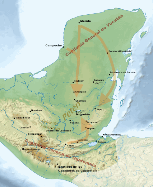
English: Routes of approach by the Spanish against the fiercely independent Itza and their neighbours during the 17th century. For layer data see File:17th century Spanish routes to Petén.xcf
Sources:
Español: Rutas de entrada de los españoles contra los itzaes y sus vecinos en el siglo XVII. Para ver datos de capas, véase File:17th century Spanish routes to Petén.xcf
Fuentes:
|
| تریخ | |
| سروت | |
| لکھاری |
|
| دوجے ورژن | العربيَّة |
| This is a retouched picture, which means that it has been digitally altered from its original version. Modifications: Cropped and added 17th century locations and battles, geographical regions etc. The original can be viewed here: Maya civilization location map-blank.svg:
|
لائسنس –
میں، اس کم دے کاپیرائٹ دا مالک، اس کم نوں اس لائسنس دے مطابق چھاپدا واں:
ایس فائل نوں کریٹو کامنز Attribution 2.5 پولینڈ لائسنس دتا گیا.
- تہانوں کھلھ اے:
- حصہ کرنا – کاپی، ونڈنا تے کم بھیجنا
- فیر رلانا – کم نوں فٹ کرنا
- تھلے دتیاں شرطاں نال:
- کس دے ناں – تسیں لازمی ایس کم دے بناں والے بارے دسو جنج اونے آکھیا اے یا جنج لسنس چ آکھیا گیا ہے۔
- اکو جہا شئیر کرو۔ – اگر تسیں بدلدے یا ایس کم تے بناندے تے بنن والے کم نوں اینج دے لسنس نال ای ونڈو گے۔
فائل دی تریخ
فائل نو اس ویلے دی حالت وچ ویکھن واسطے تاریخ/ویلے تے کلک کرو۔
| تریخ تے ویلہ | نکی مورت | پاسے | ورتن والا | تیپّݨی کرو | |
|---|---|---|---|---|---|
| موجودہ | ۰۰:۲۹, ۳۰ اپریل ۲۰۱۳ | | ۱,۱۵۲ × ۱,۴۰۴ (۵۱۶ کلوبائٹ) | Simon Burchell | +location of Dolores del Lacandón, move Ystapalapán |
| ۱۴:۳۵, ۲۸ اپریل ۲۰۱۳ |  | ۱,۱۵۲ × ۱,۴۰۴ (۵۱۵ کلوبائٹ) | Simon Burchell | +3 colonial towns in Chiapas | |
| ۱۳:۱۸, ۲۷ اپریل ۲۰۱۳ |  | ۱,۱۵۲ × ۱,۴۰۴ (۵۱۴ کلوبائٹ) | Simon Burchell | Clarify the Bacalars | |
| ۰۱:۲۲, ۲۷ اپریل ۲۰۱۳ |  | ۱,۱۵۲ × ۱,۴۰۴ (۵۱۳ کلوبائٹ) | Simon Burchell | Extend arrow towards Mérida | |
| ۲۳:۳۶, ۲۶ اپریل ۲۰۱۳ |  | ۱,۱۵۲ × ۱,۴۰۴ (۵۱۳ کلوبائٹ) | Simon Burchell | User created page with UploadWizard |
فائل دی ورتوں
تھلے دتے گئے 1 صفحے اس فائل نال جُڑدے نیں
فائل ویاپک ورتوں
ایہہ دوجے وکیاں ایس فائل نوں ورتدے نیں –
- ar.wikipedia.org تے ورتوں
- ast.wikipedia.org تے ورتوں
- en.wikipedia.org تے ورتوں
- es.wikipedia.org تے ورتوں
- eu.wikipedia.org تے ورتوں
- ja.wikipedia.org تے ورتوں
- ur.wikipedia.org تے ورتوں