
فائل:Ain al-Assad air base, 8 jan 2020.png

ایس وکھالے دا ناپ: ۸۰۰ × ۴۵۳ پکسلز۔ دوجے ریزولوشنز: ۳۲۰ × ۱۸۱ پکسلز | ۶۴۰ × ۳۶۲ پکسلز | ۱,۰۲۴ × ۵۸۰ پکسلز | ۱,۲۸۰ × ۷۲۴ پکسلز | ۲,۰۰۰ × ۱,۱۳۲ پکسلز ۔
اصل فائل (۲,۰۰۰ × ۱,۱۳۲ پکسلز, فائل حجم: ۴.۵ میگابائٹ, MIME type: image/png)
خلاصہ
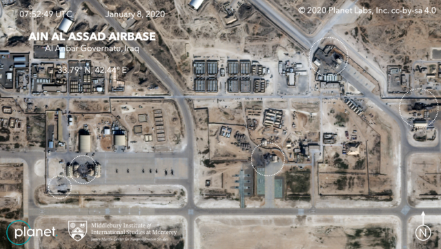
| تفصیل | Satellite image, showing the damage to at least five structures at Ain al-Assad air base in Iraq in a series of precision missile strikes launched by Iran |
| تریخ | |
| سروت |
First upload: Brumfiel, Geoff; Welna, David (8 January 2020). Satellite Photos Reveal Extent Of Damage From Iranian Strike On Air Base In Iraq. NPR. Current upload: Garger, Kenneth (8 January 2020). Before-and-after satellite images show damage to Iraqi base hit by Iran. New York Post. |
| لکھاری | Planet Labs, Inc. / Middlebury Institute of International Studies at Monterey |
| اجازت (فائل نوں دوبارہ ورتنا) |
There is a copyright notice in the upper right of this image. "© 2020 Planet Labs, Inc. cc-by-sa 4.0" |
لائسنس –
This file is licensed under the Creative Commons Attribution-Share Alike 4.0 International license.
کس دے ناں: Planet Labs, Inc.
- تہانوں کھلھ اے:
- حصہ کرنا – کاپی، ونڈنا تے کم بھیجنا
- فیر رلانا – کم نوں فٹ کرنا
- تھلے دتیاں شرطاں نال:
- کس دے ناں – تسیں لازمی ایس کم دے بناں والے بارے دسو جنج اونے آکھیا اے یا جنج لسنس چ آکھیا گیا ہے۔
- اکو جہا شئیر کرو۔ – اگر تسیں بدلدے یا ایس کم تے بناندے تے بنن والے کم نوں اینج دے لسنس نال ای ونڈو گے۔
فائل دی تریخ
فائل نو اس ویلے دی حالت وچ ویکھن واسطے تاریخ/ویلے تے کلک کرو۔
| تریخ تے ویلہ | نکی مورت | پاسے | ورتن والا | تیپّݨی کرو | |
|---|---|---|---|---|---|
| موجودہ | ۱۱:۱۴, ۹ جنوری ۲۰۲۰ | | ۲,۰۰۰ × ۱,۱۳۲ (۴.۵ میگابائٹ) | EnchanterTim | Higher resolution from: https://nypost.com/2020/01/08/before-and-after-satellite-images-show-damage-to-iraqi-base-hit-by-iran/ |
| ۰۰:۵۲, ۹ جنوری ۲۰۲۰ |  | ۸۰۰ × ۴۴۹ (۸۰۵ کلوبائٹ) | Cold Season | {{Information |Description= Satellite image, showing the damage to at least five hangars and buildings at Ain al-Assad air base in Iraq in a series of precision missile strikes launched by Iran |Source= [https://www.npr.org/2020/01/08/794517031/satellite-photos-reveal-extent-of-damage-at-al-assad-air-base?t=1578512699906 Satellite Photos Reveal Extent Of Damage From Iranian Strike On Air Base In Iraq]. NPR. |Date= 8 January 2020 |Author= Planet Labs Inc./Middlebury Institute |Permission= |ot... |
فائل دی ورتوں
تھلے دتے گئے 2 صفحے اس فائل نال جُڑدے نیں
فائل ویاپک ورتوں
ایہہ دوجے وکیاں ایس فائل نوں ورتدے نیں –
- ar.wikipedia.org تے ورتوں
- be.wikipedia.org تے ورتوں
- ca.wikipedia.org تے ورتوں
- ckb.wikipedia.org تے ورتوں
- en.wikipedia.org تے ورتوں
- es.wikipedia.org تے ورتوں
- fa.wikipedia.org تے ورتوں
- fi.wikipedia.org تے ورتوں
- fr.wikipedia.org تے ورتوں
- he.wikipedia.org تے ورتوں
- id.wikipedia.org تے ورتوں
- ja.wikipedia.org تے ورتوں
- ka.wikipedia.org تے ورتوں
- ko.wikipedia.org تے ورتوں
- nl.wikipedia.org تے ورتوں
- nl.wikinews.org تے ورتوں
- pt.wikipedia.org تے ورتوں
- ru.wikipedia.org تے ورتوں
- ru.wikinews.org تے ورتوں
- so.wikipedia.org تے ورتوں
- uk.wikipedia.org تے ورتوں
- ur.wikipedia.org تے ورتوں
- vi.wikipedia.org تے ورتوں
- www.wikidata.org تے ورتوں
- zh.wikipedia.org تے ورتوں