
فائل:China India eastern border 88.jpg

ایس وکھالے دا ناپ: ۴۸۳ × ۶۰۰ پکسلز۔ دوجے ریزولوشنز: ۱۹۳ × ۲۴۰ پکسلز | ۳۸۷ × ۴۸۰ پکسلز | ۱,۰۱۹ × ۱,۲۶۵ پکسلز ۔
اصل فائل (۱,۰۱۹ × ۱,۲۶۵ پکسلز, فائل حجم: ۲۹۷ کلوبائٹ, MIME type: image/jpeg)
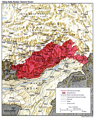
| تفصیل | China India eastern border depicting disputed areas in this sector including NEFA. | |||
| تریخ | ||||
| سروت | http://www.lib.utexas.edu/maps/middle_east_and_asia/china_india_e_border_88.jpg | |||
| لکھاری | Central Intelligence Agency | |||
| اجازت (فائل نوں دوبارہ ورتنا) |
|
|||
| دوجے ورژن |
 |

| Annotations | This image is annotated: View the annotations at Commons |
فائل دی تریخ
فائل نو اس ویلے دی حالت وچ ویکھن واسطے تاریخ/ویلے تے کلک کرو۔
| تریخ تے ویلہ | نکی مورت | پاسے | ورتن والا | تیپّݨی کرو | |
|---|---|---|---|---|---|
| موجودہ | ۰۹:۵۹, ۲ اپریل ۲۰۰۷ | | ۱,۰۱۹ × ۱,۲۶۵ (۲۹۷ کلوبائٹ) | Yuje | China India eastern border depicting disputed areas in this sector including NEFA. Taken from [http://www.lib.utexas.edu/maps/middle_east_and_asia/china_indiae_border_88.jpg] |
فائل دی ورتوں
تھلے دتے گئے 3 صفحے اس فائل نال جُڑدے نیں
فائل ویاپک ورتوں
ایہہ دوجے وکیاں ایس فائل نوں ورتدے نیں –
- as.wikipedia.org تے ورتوں
- bn.wikipedia.org تے ورتوں
- cs.wikipedia.org تے ورتوں
- de.wikipedia.org تے ورتوں
- en.wikipedia.org تے ورتوں
- es.wikipedia.org تے ورتوں
- fa.wikipedia.org تے ورتوں
- fr.wikipedia.org تے ورتوں
- gu.wikipedia.org تے ورتوں
- he.wikipedia.org تے ورتوں
- hi.wikipedia.org تے ورتوں
- hr.wikipedia.org تے ورتوں
- hu.wikipedia.org تے ورتوں
- id.wikipedia.org تے ورتوں
- it.wikipedia.org تے ورتوں
- ja.wikipedia.org تے ورتوں
- kn.wikipedia.org تے ورتوں
- ko.wikipedia.org تے ورتوں
- ky.wikipedia.org تے ورتوں
- lt.wikipedia.org تے ورتوں
- ms.wikipedia.org تے ورتوں
- ne.wikipedia.org تے ورتوں
- nl.wikipedia.org تے ورتوں
- pa.wikipedia.org تے ورتوں
- pl.wikipedia.org تے ورتوں
- pt.wikipedia.org تے ورتوں
- ru.wikipedia.org تے ورتوں
ایس فائل دا ویکھو ہور جگت ورتن .