
فائل:Gaza Strip 2011-01-20.gif
اس توں وڈی مورت موجود نہیں۔
Gaza_Strip_2011-01-20.gif (۳۳۰ × ۳۵۴ پکسلز, فائل حجم: ۱۳ کلوبائٹ, MIME type: image/gif)
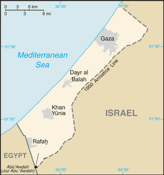
| تفصیل | Modified version of previous file, copied from the CIA World Factbook from this page: *https://www.cia.gov/library/publications/the-world-factbook/geos/gz.html |
| تریخ | (UTC) |
| سروت | |
| لکھاری |
|
| This is a retouched picture, which means that it has been digitally altered from its original version. Modifications: redacted info re current political situation and airport. The original can be viewed here: Gz-map.gif:
|
This image is in the public domain because it contains materials that originally came from the United States Central Intelligence Agency's World Factbook.
|
 |
پہلا اپلوڈ دا ریکارڈ
This image is a derivative work of the following images:
- File:Gz-map.gif licensed with PD-USGov-CIA-WF
- 2008-01-27T14:18:26Z Timeshifter 330x354 (14198 Bytes) Taken from CIA.gov map page for Gaza Strip: "This page was last updated on 24 January, 2008"
- 2008-01-27T01:58:08Z Koavf 330x354 (13178 Bytes) Removed inaccurate notice about Israeli occupation.
- 2007-12-02T14:08:51Z Timeshifter 330x354 (14198 Bytes) Nov. 15 2007 update of CIA.gov map page for Gaza Strip.
- 2005-08-15T18:09:37Z Mrmiscellanious 328x352 (9461 Bytes) Updated version of previous file, copied from CIA World Factbook on August 15, 2005.
Uploaded with derivativeFX
فائل دی تریخ
فائل نو اس ویلے دی حالت وچ ویکھن واسطے تاریخ/ویلے تے کلک کرو۔
| تریخ تے ویلہ | نکی مورت | پاسے | ورتن والا | تیپّݨی کرو | |
|---|---|---|---|---|---|
| موجودہ | ۰۶:۵۱, ۲۰ جنوری ۲۰۱۱ | | ۳۳۰ × ۳۵۴ (۱۳ کلوبائٹ) | Sjsilverman | {{Information |Description=Modified version of previous file, copied from the CIA World Factbook from this page: *https://www.cia.gov/library/publications/the-world-factbook/geos/gz.html |Source=*File:Gz-map.gif |Date=2011-0 |
فائل دی ورتوں
تھلے دتے گئے 1 صفحے اس فائل نال جُڑدے نیں
فائل ویاپک ورتوں
ایہہ دوجے وکیاں ایس فائل نوں ورتدے نیں –
- el.wikipedia.org تے ورتوں
- en.wikipedia.org تے ورتوں
- fa.wikipedia.org تے ورتوں
- fr.wikipedia.org تے ورتوں
- he.wikipedia.org تے ورتوں
- id.wikipedia.org تے ورتوں
- ko.wikipedia.org تے ورتوں
- ms.wikipedia.org تے ورتوں
- pt.wikipedia.org تے ورتوں
- ru.wikipedia.org تے ورتوں
- tr.wikipedia.org تے ورتوں
- ur.wikipedia.org تے ورتوں
- www.wikidata.org تے ورتوں
- zea.wikipedia.org تے ورتوں