
فائل:Italy and Illyria 1084 AD.svg

Size of this PNG preview of this SVG file: ۴۷۸ × ۶۰۰ پکسلز. دوجے ریزولوشنز: ۱۹۱ × ۲۴۰ پکسلز | ۳۸۳ × ۴۸۰ پکسلز | ۶۱۲ × ۷۶۸ پکسلز | ۸۱۶ × ۱,۰۲۴ پکسلز | ۱,۶۳۳ × ۲,۰۴۸ پکسلز | ۵۸۶ × ۷۳۵ پکسلز ۔
اصل فائل (ایس وی جی فائل، پکسل:۵۸۶ × ۷۳۵، فائل سائز: ۵۲۲ کلوبائٹ)

خلاصہ
| تفصیل |
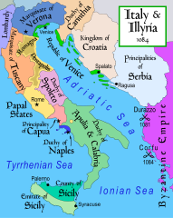
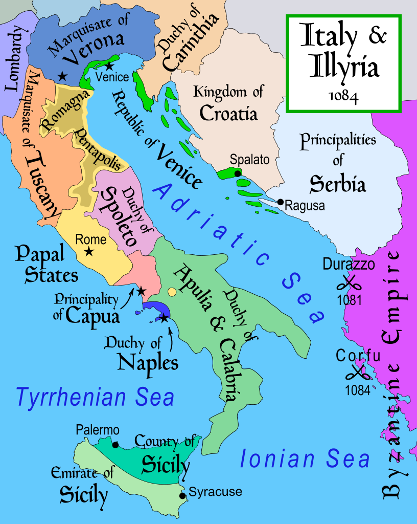
English: Map of Italy and the Illyrian coast in the year 1084.
Part of a series of maps on the history of Italy:
|
| تریخ | |
| سروت | آپݨا کم |
| لکھاری | MapMaster |
| دوجے ورژن |
[]
|
| SVG genesis |


References
- This map from Allyn & Bacon, Longman, textbook publishers.
- Bjorklund, Oddvar; Holmboe, Haakon; Rohr, Anders (1970) Historical Atlas of the World, Barnes & Noble, NY, SBN: 389-00253-4.
- Hammond Atlas Corporation (2007) Hammond Historical World Atlas.
- Matthew, Donald (1989) Atlas of Medieval Europe, Time-Life Books.
- This map of 1000 AD Italy from Fordham University, adapted from Muir's Historical Atlas, (1911).
- This map of 1050 AD Italy, from the 1923 The Historical Atlas by William R. Shepherd
- This Wikipedia map of the w:en:Holy Roman Empire
- Šišić, Ferdo (1990) Povijest Hrvata u vrijeme narodnih vladara & the Baška tablet (to denote the territorial integrity of Croatia; islands, coastal borders etc.)
لائسنس –
میں، اس کم دے کاپیرائٹ دا مالک، اس کم نوں اس لائسنس دے مطابق چھاپدا واں:
ایس فائل نوں کریٹو کامنز Attribution 2.5 جنرک لائسنس دتا گیا.
- تہانوں کھلھ اے:
- حصہ کرنا – کاپی، ونڈنا تے کم بھیجنا
- فیر رلانا – کم نوں فٹ کرنا
- تھلے دتیاں شرطاں نال:
- کس دے ناں – تسیں لازمی ایس کم دے بناں والے بارے دسو جنج اونے آکھیا اے یا جنج لسنس چ آکھیا گیا ہے۔
- اکو جہا شئیر کرو۔ – اگر تسیں بدلدے یا ایس کم تے بناندے تے بنن والے کم نوں اینج دے لسنس نال ای ونڈو گے۔
derivative works
Derivative works of this file: Italy and Illyria 1084 v2-ar.svg
فائل دی تریخ
فائل نو اس ویلے دی حالت وچ ویکھن واسطے تاریخ/ویلے تے کلک کرو۔
| تریخ تے ویلہ | نکی مورت | پاسے | ورتن والا | تیپّݨی کرو | |
|---|---|---|---|---|---|
| موجودہ | ۰۰:۱۹, ۲۳ اکتوبر ۲۰۱۷ | | ۵۸۶ × ۷۳۵ (۵۲۲ کلوبائٹ) | Ras67 | frame removed |
| ۱۷:۱۶, ۲۳ نومبر ۲۰۱۱ |  | ۵۸۸ × ۷۳۵ (۶۴۴ کلوبائٹ) | Kathovo | Reverted to version as of 12:20, 29 July 2007 not an svg | |
| ۲۳:۰۶, ۲۳ جنوری ۲۰۱۱ |  | ۴۸۰ × ۶۰۰ (۲۲۴ کلوبائٹ) | Er-vet-en | whoops, sorry for this | |
| ۲۳:۰۴, ۲۳ جنوری ۲۰۱۱ |  | ۴۸۰ × ۶۰۰ (۲۲۴ کلوبائٹ) | Er-vet-en | resize | |
| ۲۲:۵۰, ۲۳ جنوری ۲۰۱۱ |  | ۷۴۴ × ۱,۰۵۲ (۲۲۴ کلوبائٹ) | Er-vet-en | plit and some islands are are actually in Croatia's dominion from about 1076 (since the previous map relied on maps from earlier) This is proven by the acclaimed historian Ferdo Šišić, and the culturally significant Bashka tablet (which proved that ki | |
| ۱۷:۲۰, ۲۹ جولائی ۲۰۰۷ |  | ۵۸۸ × ۷۳۵ (۶۴۴ کلوبائٹ) | Lokal Profil | Cleaned up code (specifically loads of empty groups) | |
| ۱۰:۴۳, ۱۵ اپریل ۲۰۰۷ |  | ۵۸۸ × ۷۳۵ (۶۹۵ کلوبائٹ) | MapMaster | Minor changes | |
| ۰۸:۵۶, ۱۳ فروری ۲۰۰۷ |  | ۵۸۸ × ۷۳۵ (۶۹۴ کلوبائٹ) | MapMaster | Map of Italy and the Illyrian coast in the year 1084 |
فائل دی ورتوں
تھلے دتے گئے 1 صفحے اس فائل نال جُڑدے نیں
فائل ویاپک ورتوں
ایہہ دوجے وکیاں ایس فائل نوں ورتدے نیں –
- ar.wikipedia.org تے ورتوں
- azb.wikipedia.org تے ورتوں
- bg.wikipedia.org تے ورتوں
- bn.wikipedia.org تے ورتوں
- bs.wikipedia.org تے ورتوں
- ca.wikipedia.org تے ورتوں
- cs.wikipedia.org تے ورتوں
- da.wikipedia.org تے ورتوں
- de.wikipedia.org تے ورتوں
- el.wikipedia.org تے ورتوں
- en.wikipedia.org تے ورتوں
- et.wikipedia.org تے ورتوں
ایس فائل دا ویکھو ہور جگت ورتن .