
فائل:Map of the Spanish Conquest of Guatemala.png
ایس وکھالے دا ناپ: ۵۵۲ × ۵۹۹ پکسلز۔ دوجے ریزولوشنز: ۲۲۱ × ۲۴۰ پکسلز | ۴۴۲ × ۴۸۰ پکسلز | ۹۶۰ × ۱,۰۴۲ پکسلز ۔
اصل فائل (۹۶۰ × ۱,۰۴۲ پکسلز, فائل حجم: ۶۷۷ کلوبائٹ, MIME type: image/png)

|
This map image could be re-created using vector graphics as an SVG file. This has several advantages; see Commons:Media for cleanup for more information. If an SVG form of this image is available, please upload it and afterwards replace this template with
{{vector version available|new image name}}.
It is recommended to name the SVG file “Map of the Spanish Conquest of Guatemala.svg”—then the template Vector version available (or Vva) does not need the new image name parameter. |
خلاصہ
| تفصیل |
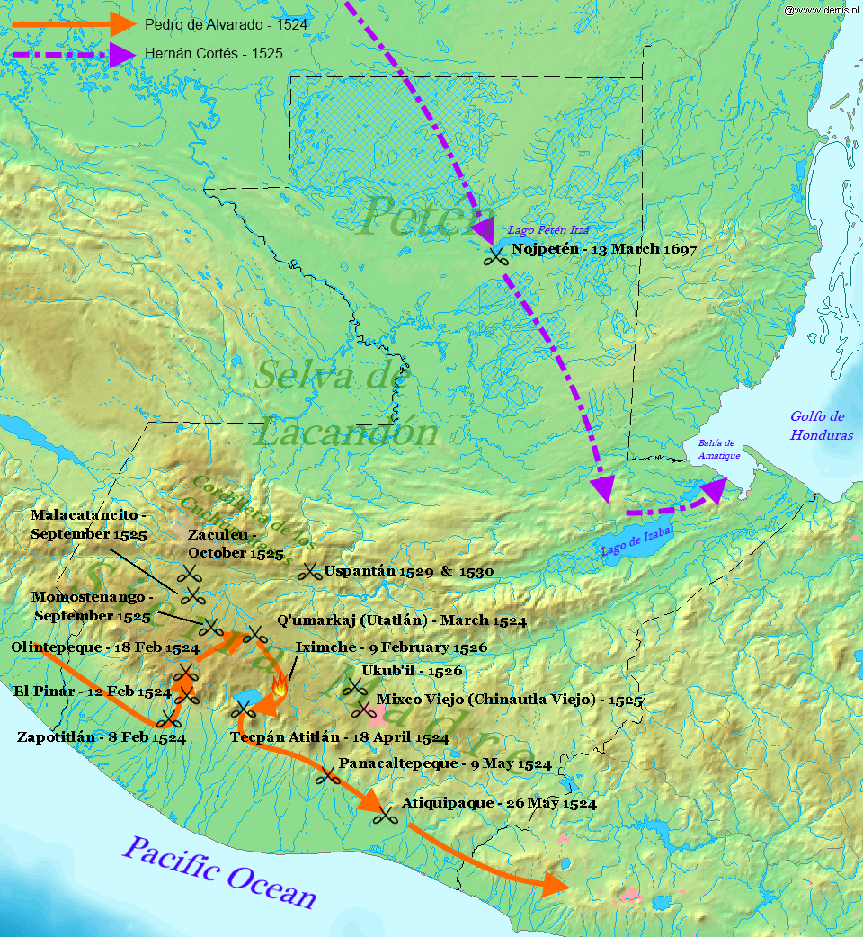
English: Map displaying the principal events of the Spanish Conquest of Guatemala, and the route taken by Pedro de Alvarado. Bounding box West -92.5°, South 13.5°, East -88°, North 18.2°. Center at 15°51′00″N 90°15′00″W / 15.85000°N 90.25000°W. |
| تریخ | (UTC) |
| سروت |
Own work using: |
| لکھاری |
|
| This is a retouched picture, which means that it has been digitally altered from its original version. Modifications: Added battles of the Spanish conquest and geographical locations. The original can be viewed here: Map of Guatemala Demis.png:
|
ایس فائل نوں کریٹو کامنز Attribution 2.5 پولینڈ لائسنس دتا گیا.
- تہانوں کھلھ اے:
- حصہ کرنا – کاپی، ونڈنا تے کم بھیجنا
- فیر رلانا – کم نوں فٹ کرنا
- تھلے دتیاں شرطاں نال:
- کس دے ناں – تسیں لازمی ایس کم دے بناں والے بارے دسو جنج اونے آکھیا اے یا جنج لسنس چ آکھیا گیا ہے۔
- اکو جہا شئیر کرو۔ – اگر تسیں بدلدے یا ایس کم تے بناندے تے بنن والے کم نوں اینج دے لسنس نال ای ونڈو گے۔
پہلا اپلوڈ دا ریکارڈ
This image is a derivative work of the following images:
- File:Map_of_Guatemala_Demis.png licensed with PD-Demis
- 2006-12-20T22:49:24Z Mats Halldin 960x1042 (507761 Bytes) Map of [[Guatemala]] Bounding box West -92.5°, South 13.5°, East -88°, North 18.2°. Center at {{coor d|15.85000|N|90.25000|W|scale:2819999}}. {{demis-pd}} [[category:maps of Guatemala]]
Uploaded with derivativeFX
فائل دی تریخ
فائل نو اس ویلے دی حالت وچ ویکھن واسطے تاریخ/ویلے تے کلک کرو۔
| تریخ تے ویلہ | نکی مورت | پاسے | ورتن والا | تیپّݨی کرو | |
|---|---|---|---|---|---|
| موجودہ | ۰۳:۳۴, ۲۹ جنوری ۲۰۱۲ | | ۹۶۰ × ۱,۰۴۲ (۶۷۷ کلوبائٹ) | Simon Burchell | +battles of Momostenango and Malacatancito, move other text make easier to read |
| ۰۱:۴۷, ۲۹ جنوری ۲۰۱۲ |  | ۹۶۰ × ۱,۰۴۲ (۶۷۷ کلوبائٹ) | Simon Burchell | +battles of Uspantán | |
| ۰۳:۱۱, ۶ اکتوبر ۲۰۱۱ |  | ۹۶۰ × ۱,۰۴۲ (۶۷۶ کلوبائٹ) | Simon Burchell | Added route of Hernán Cortés 1525 | |
| ۰۲:۲۵, ۶ اکتوبر ۲۰۱۱ |  | ۹۶۰ × ۱,۰۴۲ (۶۶۹ کلوبائٹ) | Simon Burchell | {{Information |Description=Map of Guatemala Bounding box West -92.5°, South 13.5°, East -88°, North 18.2°. Center at |Source=*File:Map_of_Guatemala_Demis.png |Date=2011-10-05 21:18 (UTC) |Author=*File:Map_of_Guatemala_Demis.png: Demis |
فائل دی ورتوں
تھلے دتے گئے 1 صفحے اس فائل نال جُڑدے نیں
فائل ویاپک ورتوں
ایہہ دوجے وکیاں ایس فائل نوں ورتدے نیں –
- ar.wikipedia.org تے ورتوں
- ca.wikipedia.org تے ورتوں
- en.wikipedia.org تے ورتوں
- es.wikipedia.org تے ورتوں
- fr.wikipedia.org تے ورتوں
- hu.wikipedia.org تے ورتوں
- it.wikipedia.org تے ورتوں
- uk.wikipedia.org تے ورتوں
- ur.wikipedia.org تے ورتوں
- vi.wikipedia.org تے ورتوں