
فائل:Patternedground.JPG
ایس وکھالے دا ناپ: ۷۲۶ × ۵۹۹ پکسلز۔ دوجے ریزولوشنز: ۲۹۱ × ۲۴۰ پکسلز | ۵۸۱ × ۴۸۰ پکسلز | ۸۶۶ × ۷۱۵ پکسلز ۔
اصل فائل (۸۶۶ × ۷۱۵ پکسلز, فائل حجم: ۱۴۳ کلوبائٹ, MIME type: image/jpeg)
خلاصہ
| تفصیل |
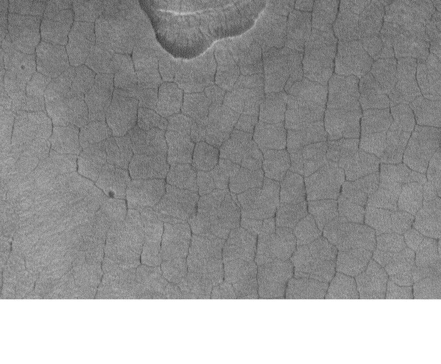
English: Patterned ground in Casius. Location is 45.06 degrees north latitude and 270.33 degrees west longitude. |
| تریخ | |
| سروت | http://www.msss.com/mars_images/moc/publicresults/2006/07/S20-00646 |
| لکھاری | Jim Secosky modified NASA image. |
لائسنس –
| This file is in the public domain in the United States because it was solely created by NASA. NASA copyright policy states that "NASA material is not protected by copyright unless noted". (See Template:PD-USGov, NASA copyright policy page or JPL Image Use Policy.) | ||
 |
Warnings:
|
پہلا اپلوڈ دا ریکارڈ
Transferred from en.wikipedia to Commons by Magnus Manske using CommonsHelper.
The original description page was here. All following user names refer to en.wikipedia.
- 2009-01-13 21:43 Jimmarsmars 866×715× (146126 bytes) {{Information |Description=Patterned ground in Casius. Location is 45.06 degrees north latitude and 270.33 degrees west longitude. |Source=http://www.msss.com/mars_images/moc/publicresults/2006/07/S20-00646 |Date=January 13, 2009 |Author=Jim Secosky modi
فائل دی تریخ
فائل نو اس ویلے دی حالت وچ ویکھن واسطے تاریخ/ویلے تے کلک کرو۔
| تریخ تے ویلہ | نکی مورت | پاسے | ورتن والا | تیپّݨی کرو | |
|---|---|---|---|---|---|
| موجودہ | ۱۳:۴۴, ۲۰ فروری ۲۰۱۱ | | ۸۶۶ × ۷۱۵ (۱۴۳ کلوبائٹ) | File Upload Bot (Magnus Manske) | {{BotMoveToCommons|en.wikipedia|year={{subst:CURRENTYEAR}}|month={{subst:CURRENTMONTHNAME}}|day={{subst:CURRENTDAY}}}} {{Information |Description={{en|Patterned ground in Casius. Location is 45.06 degrees north latitude and 270.33 degrees west longitude |
فائل دی ورتوں
تھلے دتے گئے 1 صفحے اس فائل نال جُڑدے نیں
فائل ویاپک ورتوں
ایہہ دوجے وکیاں ایس فائل نوں ورتدے نیں –
- en.wikipedia.org تے ورتوں
- es.wikipedia.org تے ورتوں
- fa.wikipedia.org تے ورتوں
- uk.wikipedia.org تے ورتوں
- ur.wikipedia.org تے ورتوں