
فائل:Road network CPEC.jpg
ایس وکھالے دا ناپ: ۷۹۹ × ۶۰۰ پکسلز۔ دوجے ریزولوشنز: ۳۲۰ × ۲۴۰ پکسلز | ۶۴۰ × ۴۸۰ پکسلز | ۹۶۲ × ۷۲۲ پکسلز ۔
اصل فائل (۹۶۲ × ۷۲۲ پکسلز, فائل حجم: ۱۳۷ کلوبائٹ, MIME type: image/jpeg)
خلاصہ
| تفصیل |
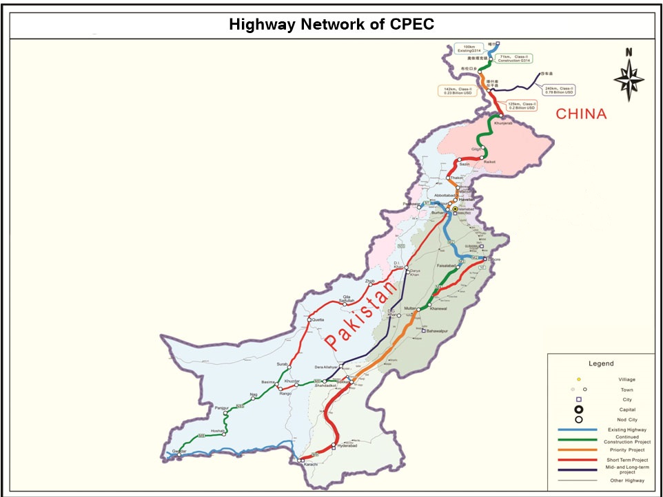
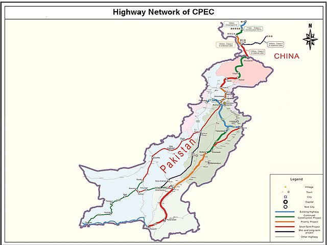
English: It describes Eastern Western and Central alignment of CPEC |
| تریخ | |
| سروت | http://www.pc.gov.pk/wp-content/uploads/2016/01/Highway-Network-of-cpac-new.jpg |
| لکھاری | Government of Pakistan |
This file is in the public domain because Planning commision of Pakistan
|
فائل دی تریخ
فائل نو اس ویلے دی حالت وچ ویکھن واسطے تاریخ/ویلے تے کلک کرو۔
| تریخ تے ویلہ | نکی مورت | پاسے | ورتن والا | تیپّݨی کرو | |
|---|---|---|---|---|---|
| موجودہ | ۰۵:۱۹, ۲۸ ستمبر ۲۰۲۳ | | ۹۶۲ × ۷۲۲ (۱۳۷ کلوبائٹ) | Eggrollll | Reverted to version as of 17:10, 4 December 2020 (UTC) |
| ۲۲:۱۱, ۴ دسمبر ۲۰۲۰ |  | ۹۶۲ × ۷۲۲ (۱۲۵ کلوبائٹ) | Pathfinder454 | Map published by user Badri2017 is forged / edited without copyrights obtained from Government of Pakistan. Original file published by user Baltistani478 is the actual map depicting road networks of CPEC as published at official website http://cpec.gov.pk/map-single/1 Therefore File Reverted to version as of 16:49, 23 May 2016 (UTC) | |
| ۲۲:۱۰, ۴ دسمبر ۲۰۲۰ |  | ۹۶۲ × ۷۲۲ (۱۳۷ کلوبائٹ) | Pathfinder454 | Reverted to version as of 10:15, 19 July 2017 (UTC) Map published by user Badri2017 is forged / edited without copyrights obtained from Government of Pakistan. Original file published by user Baltistani478 is the actual map depicting road networks of CPEC as published at official website http://cpec.gov.pk/map-single/1 Therefore File Reverted to version as of 16:49, 23 May 2016 (UTC | |
| ۲۲:۰۱, ۴ دسمبر ۲۰۲۰ |  | ۹۶۲ × ۷۲۲ (۱۲۵ کلوبائٹ) | Pathfinder454 | Map published by user Badri2017 is forged / edited without copyrights obtained from Government of Pakistan. Original file published by user Baltistani478 is the actual map depicting road networks of CPEC as published at official website http://cpec.gov.pk/map-single/1 Therefore File Reverted to version as of 16:49, 23 May 2016 (UTC) | |
| ۱۵:۱۵, ۱۹ جولائی ۲۰۱۷ |  | ۹۶۲ × ۷۲۲ (۱۳۷ کلوبائٹ) | Badri2017 | Neutral Map, Indian administered Kashmir is neither part of CPEC nor Pak territory | |
| ۲۱:۴۹, ۲۳ مئی ۲۰۱۶ |  | ۹۶۲ × ۷۲۲ (۱۲۵ کلوبائٹ) | Baltistani478 | {{subst:Upload marker added by en.wp UW}} {{Information |Description = {{en|It describes Eastern Western and Central alignment of CPEC}} |Source = http://www.pc.gov.pk/wp-content/uploads/2016/01/Highway-Network-of-cpac-new.jpg |Date = January 2016 |Aut... |
فائل دی ورتوں
تھلے دتے گئے 1 صفحے اس فائل نال جُڑدے نیں
فائل ویاپک ورتوں
ایہہ دوجے وکیاں ایس فائل نوں ورتدے نیں –
- ar.wikipedia.org تے ورتوں
- bn.wikipedia.org تے ورتوں
- ca.wikipedia.org تے ورتوں
- en.wikipedia.org تے ورتوں
- eo.wikinews.org تے ورتوں
- hi.wikipedia.org تے ورتوں
- mr.wikipedia.org تے ورتوں
- pa.wikipedia.org تے ورتوں
- sat.wikipedia.org تے ورتوں
- sd.wikipedia.org تے ورتوں
- ta.wikipedia.org تے ورتوں
- zh.wikipedia.org تے ورتوں