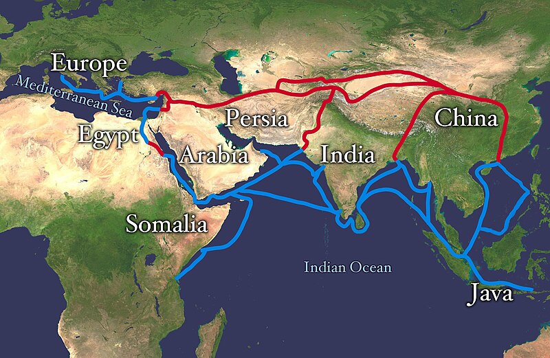
فائل:Silk route.jpg

ایس وکھالے دا ناپ: ۸۰۰ × ۵۲۱ پکسلز۔ دوجے ریزولوشنز: ۳۲۰ × ۲۰۸ پکسلز | ۶۴۰ × ۴۱۶ پکسلز | ۱,۰۲۴ × ۶۶۶ پکسلز | ۱,۲۸۰ × ۸۳۳ پکسلز | ۲,۸۶۸ × ۱,۸۶۶ پکسلز ۔
اصل فائل (۲,۸۶۸ × ۱,۸۶۶ پکسلز, فائل حجم: ۸۱۹ کلوبائٹ, MIME type: image/jpeg)
فائل دی تریخ
فائل نو اس ویلے دی حالت وچ ویکھن واسطے تاریخ/ویلے تے کلک کرو۔
| تریخ تے ویلہ | نکی مورت | پاسے | ورتن والا | تیپّݨی کرو | |
|---|---|---|---|---|---|
| موجودہ | ۱۵:۳۸, ۴ جولائی ۲۰۱۸ |  | ۲,۸۶۸ × ۱,۸۶۶ (۸۱۹ کلوبائٹ) | Bongan | sea route modify because of Rama Setu ({{Adam's Bridge}}) |
| ۱۹:۰۱, ۸ فروری ۲۰۱۸ |  | ۲,۸۶۸ × ۱,۸۶۶ (۱.۵۷ میگابائٹ) | Darwgon0801 | Reverted to version as of 17:45, 30 December 2012 (UTC) | |
| ۱۲:۴۲, ۲۲ نومبر ۲۰۱۷ |  | ۲,۸۶۸ × ۱,۸۶۶ (۲.۰۶ میگابائٹ) | Ibrahim Muizzuddin | Reverted to version as of 13:19, 12 April 2012 (UTC) Revert to more credible version | |
| ۲۲:۴۵, ۳۰ دسمبر ۲۰۱۲ |  | ۲,۸۶۸ × ۱,۸۶۶ (۱.۵۷ میگابائٹ) | 23prootie~commonswiki | Adding Brunei and the Lucoes | |
| ۱۸:۱۹, ۱۲ اپریل ۲۰۱۲ |  | ۲,۸۶۸ × ۱,۸۶۶ (۲.۰۶ میگابائٹ) | Splette | correct typo | |
| ۱۵:۱۵, ۱۲ اپریل ۲۰۱۲ |  | ۲,۸۶۸ × ۱,۸۶۶ (۲.۰۶ میگابائٹ) | Splette | correct the position of the 'Somalia' label | |
| ۰۹:۵۱, ۲۷ مئی ۲۰۱۰ |  | ۲,۸۶۸ × ۱,۸۶۶ (۱.۹۳ میگابائٹ) | Splette | one more try... better contrast | |
| ۰۹:۴۵, ۲۷ مئی ۲۰۱۰ |  | ۲,۸۶۸ × ۱,۸۶۶ (۱.۹۴ میگابائٹ) | Splette | change colors | |
| ۰۹:۳۷, ۲۷ مئی ۲۰۱۰ |  | ۲,۸۶۸ × ۱,۸۶۶ (۱.۹۳ میگابائٹ) | Splette | {{Information |Description=Extent of Silk Route/Silk Road. Red is land route and the blue is the sea/water route. |Source=*File:Whole_world_-_land_and_oceans_12000.jpg |Date=2010-05-27 04:33 (UTC) |Author=*[[:File:Whole_world_-_land_and_oceans_12000 |
فائل دی ورتوں
تھلے دتے گئے 3 صفحے اس فائل نال جُڑدے نیں
فائل ویاپک ورتوں
ایہہ دوجے وکیاں ایس فائل نوں ورتدے نیں –
- af.wikipedia.org تے ورتوں
- anp.wikipedia.org تے ورتوں
- ast.wikipedia.org تے ورتوں
- azb.wikipedia.org تے ورتوں
- az.wikipedia.org تے ورتوں
- ba.wikipedia.org تے ورتوں
- be-tarask.wikipedia.org تے ورتوں
- bg.wikipedia.org تے ورتوں
- bn.wikipedia.org تے ورتوں
- bs.wikipedia.org تے ورتوں
- ca.wikipedia.org تے ورتوں
- ce.wikipedia.org تے ورتوں
- chr.wikipedia.org تے ورتوں
- crh.wikipedia.org تے ورتوں
- da.wikipedia.org تے ورتوں
- de.wikipedia.org تے ورتوں
- el.wikipedia.org تے ورتوں
- el.wikivoyage.org تے ورتوں
- en.wikipedia.org تے ورتوں
ایس فائل دا ویکھو ہور جگت ورتن .


