
فائل:The Border on Killeen School Road - geograph.org.uk - 446719.jpg
اس توں وڈی مورت موجود نہیں۔
The_Border_on_Killeen_School_Road_-_geograph.org.uk_-_446719.jpg (۶۴۰ × ۴۸۰ پکسلز, فائل حجم: ۷۱ کلوبائٹ, MIME type: image/jpeg)
خلاصہ
| تفصیل |
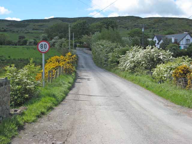
English: The Irish Border between Northern Ireland and Ireland on Killeen School Road in Killeen, County Armagh, in Northern Ireland. The only indication that one is crossing into the Republic of Ireland is the speed limit sign expressed in kilometres per hour. There are no indications when one is travelling in the opposite direction. The Cooley Mountains are in the background. |
| تریخ | |
| سروت | From geograph.org.uk |
| لکھاری | Oliver Dixon |
| کس دے ناں (required by the license) | Oliver Dixon / The Border on Killeen School Road / |
| Camera location | | View this and other nearby images on: OpenStreetMap |
|---|
_heading:202.00&language=pnb)
| Object location | | View this and other nearby images on: OpenStreetMap |
|---|
_heading:202.00&language=pnb)
لائسنس –

|
This image was taken from the Geograph project collection. See this photograph's page on the Geograph website for the photographer's contact details. The copyright on this image is owned by Oliver Dixon and is licensed for reuse under the Creative Commons Attribution-ShareAlike 2.0 license.
|
ایس فائل نوں کریٹو کامنز Attribution 2.0 جنرک لائسنس دتا گیا.
کس دے ناں: Oliver Dixon
- تہانوں کھلھ اے:
- حصہ کرنا – کاپی، ونڈنا تے کم بھیجنا
- فیر رلانا – کم نوں فٹ کرنا
- تھلے دتیاں شرطاں نال:
- کس دے ناں – تسیں لازمی ایس کم دے بناں والے بارے دسو جنج اونے آکھیا اے یا جنج لسنس چ آکھیا گیا ہے۔
- اکو جہا شئیر کرو۔ – اگر تسیں بدلدے یا ایس کم تے بناندے تے بنن والے کم نوں اینج دے لسنس نال ای ونڈو گے۔
فائل دی تریخ
فائل نو اس ویلے دی حالت وچ ویکھن واسطے تاریخ/ویلے تے کلک کرو۔
| تریخ تے ویلہ | نکی مورت | پاسے | ورتن والا | تیپّݨی کرو | |
|---|---|---|---|---|---|
| موجودہ | ۱۷:۴۵, ۴ فروری ۲۰۱۱ | | ۶۴۰ × ۴۸۰ (۷۱ کلوبائٹ) | GeographBot | == {{int:filedesc}} == {{Information |description={{en|1=The Border on Killeen School Road The only indication that one is crossing into the Irish Republic is the speed limit sign expressed in Kilometres per hour. Cooley Mountains in the background.}} |da |
فائل دی ورتوں
تھلے دتے گئے 1 صفحے اس فائل نال جُڑدے نیں
فائل ویاپک ورتوں
ایہہ دوجے وکیاں ایس فائل نوں ورتدے نیں –
- ar.wikipedia.org تے ورتوں
- ca.wikipedia.org تے ورتوں
- de.wikipedia.org تے ورتوں
- en.wikipedia.org تے ورتوں
- en.wikivoyage.org تے ورتوں
- fr.wikipedia.org تے ورتوں
- id.wikipedia.org تے ورتوں
- it.wikipedia.org تے ورتوں
- ja.wikipedia.org تے ورتوں
- ko.wikipedia.org تے ورتوں
- ms.wikipedia.org تے ورتوں
- no.wikipedia.org تے ورتوں
- pt.wikipedia.org تے ورتوں
- ru.wikipedia.org تے ورتوں
- sd.wikipedia.org تے ورتوں
- uk.wikipedia.org تے ورتوں
- ur.wikipedia.org تے ورتوں
- www.wikidata.org تے ورتوں