
فائل:Urartu 715 713-en.svg

Size of this PNG preview of this SVG file: ۸۰۰ × ۵۱۳ پکسلز. دوجے ریزولوشنز: ۳۲۰ × ۲۰۵ پکسلز | ۶۴۰ × ۴۱۰ پکسلز | ۱,۰۲۴ × ۶۵۷ پکسلز | ۱,۲۸۰ × ۸۲۱ پکسلز | ۲,۵۶۰ × ۱,۶۴۱ پکسلز | ۲,۷۱۴ × ۱,۷۴۰ پکسلز ۔
اصل فائل (ایس وی جی فائل، پکسل:۲,۷۱۴ × ۱,۷۴۰، فائل سائز: ۸۸۱ کلوبائٹ)
خلاصہ
| تفصیل |
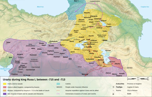
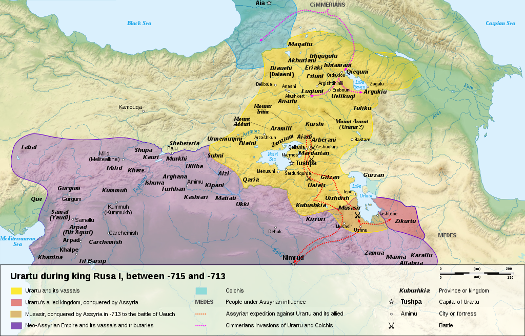
English: Map of the kingdom of Urartu, between -715 and -713.
Français : Carte en anglais du royaume d'Urartu, entre -715 et -713. |
||
| تریخ | |||
| سروت |
Own work.
Sources :
Software used :
Other data :
|
||
| لکھاری | Sémhur | ||
| دوجے ورژن |
See Urartu.
| ||
| کس دے ناں (required by the license) | © Sémhur / Wikimedia Commons / | ||
| SVG | W3C-validity not checked.
|
||
| Atelier graphique |


| Camera location | | View this and other nearby images on: OpenStreetMap |
|---|
لائسنس –
میں، اس کم دے کاپیرائٹ دا مالک، اس کم نوں اس لائسنس دے مطابق چھاپدا واں:
| کاپی حق چھڈیا: آرٹ دا ایہ کم کھلا اے؛ تسیں اینوں ونڈ سکدے او یا بدل سکدے او Free Art License دیاں شرطاں نال۔ تسیں ایدے لسنس دی اک ادھارن Copyleft Attitude site تے Copyleft Attitude site تے ہور سائیٹاں تے لب سکدے او |
This file is licensed under the Creative Commons Attribution-Share Alike 4.0 International, 3.0 Unported, 2.5 Generic, 2.0 Generic and 1.0 Generic license.
- تہانوں کھلھ اے:
- حصہ کرنا – کاپی، ونڈنا تے کم بھیجنا
- فیر رلانا – کم نوں فٹ کرنا
- تھلے دتیاں شرطاں نال:
- کس دے ناں – تسیں لازمی ایس کم دے بناں والے بارے دسو جنج اونے آکھیا اے یا جنج لسنس چ آکھیا گیا ہے۔
- اکو جہا شئیر کرو۔ – اگر تسیں بدلدے یا ایس کم تے بناندے تے بنن والے کم نوں اینج دے لسنس نال ای ونڈو گے۔
تسیں اپنی مرضی دا لائسنس چݨ سکدے اوہ۔
| Annotations | This image is annotated: View the annotations at Commons |
فائل دی تریخ
فائل نو اس ویلے دی حالت وچ ویکھن واسطے تاریخ/ویلے تے کلک کرو۔
| تریخ تے ویلہ | نکی مورت | پاسے | ورتن والا | تیپّݨی کرو | |
|---|---|---|---|---|---|
| موجودہ | ۲۱:۱۵, ۱۰ جنوری ۲۰۰۸ | | ۲,۷۱۴ × ۱,۷۴۰ (۸۸۱ کلوبائٹ) | Sémhur | == Description == {{Information |Description= {{en| Map of the kingdom of Urartu, between -715 and -713.}} {{fr| Carte en anglais du royaume d'Urartu, entre -715 et -713.}} |Source=Own work. {{clr}} Sources : * Topographic background : [http://www2.jpl.na |
فائل دی ورتوں
تھلے دتے گئے 1 صفحے اس فائل نال جُڑدے نیں
فائل ویاپک ورتوں
ایہہ دوجے وکیاں ایس فائل نوں ورتدے نیں –
- als.wikipedia.org تے ورتوں
- ast.wikipedia.org تے ورتوں
- avk.wikipedia.org تے ورتوں
- azb.wikipedia.org تے ورتوں
- bg.wikipedia.org تے ورتوں
- ckb.wikipedia.org تے ورتوں
- cs.wikipedia.org تے ورتوں
- de.wikipedia.org تے ورتوں
- en.wikipedia.org تے ورتوں
- eo.wikipedia.org تے ورتوں
- et.wikipedia.org تے ورتوں
- fr.wikipedia.org تے ورتوں
- fy.wikipedia.org تے ورتوں
- gl.wikipedia.org تے ورتوں
- hy.wikipedia.org تے ورتوں
- id.wikipedia.org تے ورتوں
- ja.wikipedia.org تے ورتوں
- ka.wikipedia.org تے ورتوں
- mt.wikipedia.org تے ورتوں
- no.wikipedia.org تے ورتوں
- pl.wikipedia.org تے ورتوں
- sl.wikipedia.org تے ورتوں
- sr.wikipedia.org تے ورتوں
ایس فائل دا ویکھو ہور جگت ورتن .