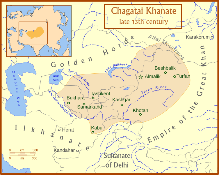
فائل:Chagatai Khanate map en.svg

Size of this PNG preview of this SVG file: ۷۵۳ × ۶۰۰ پکسلز. دوجے ریزولوشنز: ۳۰۱ × ۲۴۰ پکسلز | ۶۰۳ × ۴۸۰ پکسلز | ۹۶۴ × ۷۶۸ پکسلز | ۱,۲۸۰ × ۱,۰۲۰ پکسلز | ۲,۵۶۰ × ۲,۰۳۹ پکسلز | ۸۱۱ × ۶۴۶ پکسلز ۔
اصل فائل (ایس وی جی فائل، پکسل:۸۱۱ × ۶۴۶، فائل سائز: ۴۶۸ کلوبائٹ)
فائل دی تریخ
فائل نو اس ویلے دی حالت وچ ویکھن واسطے تاریخ/ویلے تے کلک کرو۔
| تریخ تے ویلہ | نکی مورت | پاسے | ورتن والا | تیپّݨی کرو | |
|---|---|---|---|---|---|
| موجودہ | ۰۹:۵۰, ۱۵ جولائی ۲۰۰۸ |  | ۸۱۱ × ۶۴۶ (۴۶۸ کلوبائٹ) | MapMaster | +river name, + colour adjustment |
| ۰۹:۱۳, ۱۵ جولائی ۲۰۰۸ |  | ۸۱۱ × ۶۴۶ (۴۵۴ کلوبائٹ) | MapMaster | made a few corrections to version | |
| ۰۹:۰۷, ۱۵ جولائی ۲۰۰۸ |  | ۸۱۱ × ۶۴۶ (۴۲۶ کلوبائٹ) | MapMaster | {{Information |Description={{en|1=A map of the Chagatai Khanate, late 13th century}} |Source=Own work by uploader |Author=MapMaster |Date=14 July 2008 |Permission= |other_versions= }} {{ImageUpload|full}} |
فائل دی ورتوں
تھلے دتے گئے 2 صفحے اس فائل نال جُڑدے نیں
فائل ویاپک ورتوں
ایہہ دوجے وکیاں ایس فائل نوں ورتدے نیں –
- azb.wikipedia.org تے ورتوں
- az.wikipedia.org تے ورتوں
- bg.wikipedia.org تے ورتوں
- bn.wikipedia.org تے ورتوں
- ca.wikipedia.org تے ورتوں
- ce.wikipedia.org تے ورتوں
- crh.wikipedia.org تے ورتوں
- da.wikipedia.org تے ورتوں
- de.wikipedia.org تے ورتوں
- el.wikipedia.org تے ورتوں
- en.wikipedia.org تے ورتوں
- eo.wikipedia.org تے ورتوں
- et.wikipedia.org تے ورتوں
- fr.wikipedia.org تے ورتوں
- he.wikipedia.org تے ورتوں
- hi.wikipedia.org تے ورتوں
- hr.wikipedia.org تے ورتوں
- hu.wikipedia.org تے ورتوں
- it.wikipedia.org تے ورتوں
- ja.wikipedia.org تے ورتوں
- kk.wikipedia.org تے ورتوں
- ko.wikipedia.org تے ورتوں
- lt.wikipedia.org تے ورتوں
- mk.wikipedia.org تے ورتوں
- mn.wikipedia.org تے ورتوں
- nl.wikipedia.org تے ورتوں
- oc.wikipedia.org تے ورتوں
- pl.wikipedia.org تے ورتوں
- ru.wikipedia.org تے ورتوں
ایس فائل دا ویکھو ہور جگت ورتن .
