
الاباما دیاں کاؤنٹیاں
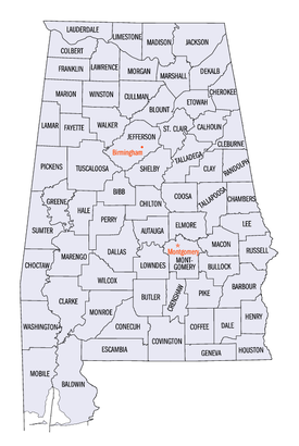
امریکی ریاست الاباما دیاں 67 کاؤنٹیاں نیں۔ [۱]
کاؤنٹیاں
[سودھو]| کاؤنٹی |
ایف آئی پی ایس کوڈ [۲] |
کاؤنٹی نشست [۳] |
لائسنس # [۴] |
تشکیل [۳] |
سے قائم [۵] |
اشتقاقیات [۶][۷] |
کثافت |
آبادی [۸] |
رقبہ [۹] |
نقشہ |
|---|---|---|---|---|---|---|---|---|---|---|
| Autauga County | 001 | Prattville | 4 | 1818 | Montgomery County | The Autauga or Atagi people, Native Americans who were a sub-group of the Alibamu | 93.46 | ۵۵,۵۱۴ | ۵۹۴ sq mi (1,538 km2) | 
|
| Baldwin County | 003 | Bay Minette | 5 | 1809 | Washington County and West Florida | Abraham Baldwin (1754–1807), U.S. legislator from Georgia | 119.99 | ۱۹۰,۷۹۰ | ۱,۵۹۰ sq mi (۴,۱۱۸ km2) |

|
| Barbour County | 005 | Clayton | 6 | 1832 | Pike County | James Barbour (1775–1842), Governor of Virginia and U.S. Senator | 30.74 | ۲۷,۲۰۱ | ۸۸۵ sq mi (۲,۲۹۲ km2) |

|
| Bibb County | 007 | Centreville | 7 | 1818 | Montgomery County (as Cahawba County) | William Wyatt Bibb (1781–1820), 1st Governor of Alabama | 36.27 | ۲۲,۵۹۷ | ۶۲۳ sq mi (۱,۶۱۴ km2) |

|
| Blount County | 009 | Oneonta | 8 | 1818 | Montgomery County and Indian territories | Willie Blount (1768–1835), Governor of Tennessee. | 89.65 | ۵۷,۸۲۶ | ۶۴۵ sq mi (۱,۶۷۱ km2) |

|
| Bullock County | 011 | Union Springs | 9 | 1866 | Barbour, Macon, Montgomery, and Pike counties | Edward Bullock (1822–1861), colonel in the Confederate States Army | 16.81 | ۱۰,۴۷۴ | ۶۲۳ sq mi (۱,۶۱۴ km2) |

|
| Butler County | 013 | Greenville | 10 | 1819 | Conecuh and Monroe counties | William Butler (?–1818), captain in Creek War | 26.14 | ۲۰,۳۰۷ | ۷۷۷ sq mi (۲,۰۱۲ km2) |

|
| Calhoun County | 015 | Anniston | 11 | 1832 | St. Clair County (as Benton County) | John C. Calhoun (1782–1850), 7th U.S. Vice President | 193.56 | ۱۱۷,۲۹۶ | ۶۰۶ sq mi (۱,۵۷۰ km2) |

|
| Chambers County | 017 | LaFayette | 12 | 1832 | Montgomery County | Henry H. Chambers (1790–1826), U.S. Senator | 57.06 | ۳۴,۰۶۴ | ۵۹۷ sq mi (۱,۵۴۶ km2) |

|
| Cherokee County | 019 | Centre | 13 | 1836 | چروکی territory | چروکی people, whose lands included Alabama | 46.97 | ۲۶,۰۲۱ | ۵۵۴ sq mi (۱,۴۳۵ km2) |

|
| Chilton County | 021 | Clanton | 14 | 1868 | Autauga, Bibb, Perry, and Shelby counties (as Baker County) | William Parish Chilton (1810–1871), Alabama Supreme Court Justice and Confederate congressman | 63.23 | ۴۳,۸۱۹ | ۶۹۳ sq mi (۱,۷۹۵ km2) |

|
| Choctaw County | 023 | Butler | 15 | 1847 | Sumter and Washington counties | Choctaw people, whose lands included Alabama | 14.92 | ۱۳,۶۳۳ | ۹۱۴ sq mi (۲,۳۶۷ km2) |

|
| Clarke County | 025 | Grove Hill | 16 | 1812 | Washington County | John Clarke (1766–1832), general from Georgia | 20.32 | ۲۵,۱۶۱ | ۱,۲۳۸ sq mi (۳,۲۰۶ km2) |

|
| Clay County | 027 | Ashland | 17 | 1866 | Randolph and Talladega counties | Henry Clay (1777–1852), U.S. legislator from کینٹکی | 22.24 | ۱۳,۴۳۵ | ۶۰۴ sq mi (۱,۵۶۴ km2) |

|
| Cleburne County | 029 | Heflin | 18 | 1866 | Calhoun, Randolph , and Talladega counties | Patrick Cleburne (1828–1864), major general in Confederate States Army | 26.49 | ۱۴,۸۳۲ | ۵۶۰ sq mi (۱,۴۵۰ km2) |

|
| Coffee County | 031 | Elba and Enterprise[۱۰] | 19 | 1841 | Dale County | John Coffee (1772–1833), military leader in War of 1812 and Creek War | 75.48 | ۵۱,۲۵۲ | ۶۷۹ sq mi (۱,۷۵۹ km2) |

|
| Colbert County | 033 | Tuscumbia | 20 | 1867 | Franklin County | George Colbert (1764–1839) and Levi Colbert (1759–1834), Chickasaw chiefs | 91.81 | ۵۴,۴۴۶ | ۵۹۳ sq mi (۱,۵۳۶ km2) |

|
| Conecuh County | 035 | Evergreen | 21 | 1818 | Monroe County | The Conecuh River, which flows through the county | 15.27 | ۱۲,۹۸۱ | ۸۵۰ sq mi (۲,۲۰۱ km2) |

|
| Coosa County | 037 | Rockford | 22 | 1832 | Montgomery County | The Coosa River, which flows through the county, and is itself named after a Native American village | 16.84 | ۱۰,۹۶۶ | ۶۵۱ sq mi (۱,۶۸۶ km2) |

|
| Covington County | 039 | Andalusia | 23 | 1821 | Henry County | Leonard Covington (1768–1813), brigadier general in War of 1812 and U.S. Congressman | 36.85 | ۳۷,۹۵۵ | ۱,۰۳۰ sq mi (۲,۶۶۸ km2) |

|
| Crenshaw County | 041 | Luverne | 24 | 1866 | Butler, Coffee, Covington, Lowndes, and Pike Counties | Anderson Crenshaw (1783–1847), Alabama Supreme Court justice and early settler | 23.12 | ۱۴,۰۸۳ | ۶۰۹ sq mi (۱,۵۷۷ km2) |

|
| Cullman County | 043 | Cullman | 25 | 1877 | Blount, Morgan, and Winston counties | Colonel John G. Cullmann (1823–1895), founder of county seat | 109.44 | ۸۰,۴۴۰ | ۷۳۵ sq mi (۱,۹۰۴ km2) |

|
| Dale County | 045 | Ozark | 26 | 1824 | Covington and Henry counties | Samuel Dale (1772–1841), brigadier general and state legislator | 89.92 | ۵۰,۴۴۴ | ۵۶۱ sq mi (۱,۴۵۳ km2) |

|
| Dallas County | 047 | Selma | 27 | 1818 | Monroe and Montgomery counties | Alexander James Dallas (1759–1817) , U.S. Secretary of Treasury | 44.76 | ۴۳,۸۲۰ | ۹۷۹ sq mi (۲,۵۳۶ km2) |

|
| DeKalb County | 049 | Fort Payne | 28 | 1836 | چروکی territory | Johann de Kalb (1721–1780), major general in امریکی جنگ انقلاب | 91.52 | ۷۱,۱۰۹ | ۷۷۷ sq mi (۲,۰۱۲ km2) |

|
| Elmore County | 051 | Wetumpka | 29 | 1866 | Autauga, Coosa, Montgomery, and Tallapoosa counties | John Archer Elmore (1762–1834), Revolutionary War veteran | 128.32 | ۷۹,۳۰۳ | ۶۱۸ sq mi (۱,۶۰۱ km2) |

|
| Escambia County | 053 | Brewton | 30 | 1868 | Baldwin and Conecuh counties | Escambia Creek, a tributary of the Conecuh River | 40.55 | ۳۸,۳۱۹ | ۹۴۵ sq mi (۲,۴۴۸ km2) |

|
| Etowah County | 055 | Gadsden | 31 | 1866 | Blount, Calhoun, Cherokee, DeKalb, Marshall, and St. Clair counties (as Baine County) | Etowah Indian Mounds | 195.20 | ۱۰۴,۴۳۰ | ۵۳۵ sq mi (۱,۳۸۶ km2) |

|
| Fayette County | 057 | Fayette | 32 | 1824 | Marion, Pickens, Tuscaloosa, and Walker counties | Marquis de La Fayette (1757–1834), Revolutionary War commander | 27.45 | ۱۷,۲۴۱ | ۶۲۸ sq mi (۱,۶۲۷ km2) |

|
| Franklin County | 059 | Russellville | 33 | 1818 | چروکی territory | بن یمین فرینکلن (1706–1790), politician, diplomat, inventor, and publisher | 50.01 | ۳۱,۷۰۴ | ۶۳۴ sq mi (۱,۶۴۲ km2) |

|
| Geneva County | 061 | Geneva | 34 | 1868 | Coffee, Dale, and Henry counties | Named after Geneva, New York, the origin of several early settlers | 46.67 | ۲۶,۷۹۰ | ۵۷۴ sq mi (۱,۴۸۷ km2) |

|
| Greene County | 063 | Eutaw | 35 | 1819 | Marengo and Tuscaloosa counties | Nathanael Greene (1742–1786), Revolutionary War general | 13.98 | ۹,۰۴۵ | ۶۴۷ sq mi (۱,۶۷۶ km2) |

|
| Hale County | 065 | Greensboro | 36 | 1867 | Greene, Marengo, Perry, and Tuscaloosa counties | Stephen F. Hale (1816–1862), lieutenant colonel in Confederate States Army | 24.47 | ۱۵,۷۶۰ | ۶۴۴ sq mi (۱,۶۶۸ km2) |

|
| Henry County | 067 | Abbeville | 37 | 1819 | Conecuh County | Patrick Henry (1736–1799), Revolutionary War patriot and Governor of Virginia | 30.79 | ۱۷,۳۰۲ | ۵۶۲ sq mi (۱,۴۵۶ km2) |

|
| Houston County | 069 | Dothan | 38 | 1903 | Dale, Geneva, and Henry counties | George S. Houston (1811–1879), 24th Governor of Alabama and U.S. Congressman | 175.08 | ۱۰۱,۵۴۷ | ۵۸۰ sq mi (۱,۵۰۲ km2) |

|
| Jackson County | 071 | Scottsboro | 39 | 1819 | چروکی territory | اینڈریو جیکسن (1767–1845), 7th U.S. President | 49.38 | ۵۳,۲۲۷ | ۱,۰۷۸ sq mi (۲,۷۹۲ km2) |

|
| Jefferson County | 073 | Birmingham | 1 | 1819 | Blount County | ٹامس جیفرسن (1743–1826), 3rd U.S. President | 592.68 | ۶۵۸,۴۶۶ | ۱,۱۱۱ sq mi (۲,۸۷۷ km2) |

|
| Lamar County | 075 | Vernon | 40 | 1867 | Fayette and Marion counties (as Jones County) | Lucius Q. C. Lamar (1825–1893), U.S. Supreme Court justice | 24.07 | ۱۴,۵۶۴ | ۶۰۵ sq mi (۱,۵۶۷ km2) |

|
| Lauderdale County | 077 | Florence | 41 | 1818 | چروکی and Chickasaw territories | James Lauderdale (1780–1814), Colonel in War of 1812 | 138.79 | ۹۲,۷۰۹ | ۶۶۸ sq mi (۱,۷۳۰ km2) |

|
| Lawrence County | 079 | Moulton | 42 | 1818 | چروکی territory | James Lawrence (1781–1813), naval officer in War of 1812 | 49.69 | ۳۴,۳۳۹ | ۶۹۱ sq mi (۱,۷۹۰ km2) |

|
| Lee County | 081 | Opelika | 43 | 1866 | Chambers, Macon, Russell, and Tallapoosa counties | Robert E. Lee (1807–1870), Commander of the Confederate States Army | 230.67 | ۱۴۰,۲۴۷ | ۶۰۸ sq mi (۱,۵۷۵ km2) |

|
| Limestone County | 083 | Athens | 44 | 1818 | Elk and Madison counties | Limestone Creek, named for local geological deposits | 147.83 | ۸۲,۷۸۲ | ۵۶۰ sq mi (۱,۴۵۰ km2) |

|
| Lowndes County | 085 | Hayneville | 45 | 1830 | Butler, Dallas, and Montgomery counties | William Lowndes (1782–1822), U.S. Congressman from جنوبی کیرولائنا | 15.78 | ۱۱,۲۹۹ | ۷۱۶ sq mi (۱,۸۵۴ km2) |

|
| Macon County | 087 | Tuskegee | 46 | 1832 | Montgomery County | Nathaniel Macon (1758–1837), U.S. legislator from شمالی کیرولائنا | 35.22 | ۲۱,۴۵۲ | ۶۰۹ sq mi (۱,۵۷۷ km2) |

|
| Madison County | 089 | Huntsville | 47 | 1808 | چروکی and Chickasaw territories | James Madison (1751–1836), 4th U.S. President | 417.47 | ۳۳۴,۸۱۱ | ۸۰۲ sq mi (۲,۰۷۷ km2) |

|
| Marengo County | 091 | Linden | 48 | 1818 | Choctaw territory | Battle of Marengo | 21.52 | ۲۱,۰۲۷ | ۹۷۷ sq mi (۲,۵۳۰ km2) |

|
| Marion County | 093 | Hamilton | 49 | 1818 | Tuscaloosa County | Francis Marion (1732–1795), military leader in امریکی جنگ انقلاب | 41.48 | ۳۰,۷۷۶ | ۷۴۲ sq mi (۱,۹۲۲ km2) |

|
| Marshall County | 095 | Guntersville | 50 | 1836 | Blount and Jackson counties and چروکی territory | John Marshall (1755–1835), Chief Justice of the United States 1801–1835 | 164.34 | ۹۳,۰۱۹ | ۵۶۶ sq mi (۱,۴۶۶ km2) |

|
| Mobile County | 097 | Mobile | 2 | 1812 | Mobile District of West Florida after annexation into Mississippi Territory | Mobile Bay, on which county is located, and which is itself named after the Maubila tribe of Native Americans | 336.04 | ۴۱۲,۹۹۲ | ۱,۲۲۹ sq mi (۳,۱۸۳ km2) |

|
| Monroe County | 099 | Monroeville | 51 | 1815 | Creek territory | جیمز مونرو (1758–1831), 5th U.S. President | 22.48 | ۲۳,۰۶۸ | ۱,۰۲۶ sq mi (۲,۶۵۷ km2) |

|
| Montgomery County | 101 | Montgomery | 3 | 1816 | Monroe County | Lemuel P. Montgomery (1786–1814), Major in Creek War | 292.55 | ۲۲۹,۳۶۳ | ۷۸۴ sq mi (۲,۰۳۱ km2) |

|
| Morgan County | 103 | Decatur | 52 | 1818 | چروکی territory (as Cotaco County) | Daniel Morgan (1736–1802), U.S. Congressman | 206.37 | ۱۱۹,۴۹۰ | ۵۷۹ sq mi (۱,۵۰۰ km2) |

|
| Perry County | 105 | Marion | 53 | 1819 | Cahawba, Dallas, Marengo, and Tuscaloosa counties | Oliver Hazard Perry (1795–1819), naval officer in War of 1812 | 14.71 | ۱۰,۵۹۱ | ۷۲۰ sq mi (۱,۸۶۵ km2) |

|
| Pickens County | 107 | Carrollton | 54 | 1820 | Tuscaloosa County | Andrew Pickens (1739–1817), General in the Revolutionary War | 22.41 | ۱۹,۷۴۶ | ۸۸۱ sq mi (۲,۲۸۲ km2) |

|
| Pike County | 109 | Troy | 55 | 1821 | Henry and Montgomery counties | Zebulon Pike (1779–1813), explorer and officer in War of 1812 | 48.96 | ۳۲,۸۹۹ | ۶۷۲ sq mi (۱,۷۴۰ km2) |

|
| Randolph County | 111 | Wedowee | 56 | 1832 | St. Clair and Shelby counties | John Randolph (1773–1833), U.S. Senator from ورجینیا | 39.44 | ۲۲,۹۱۳ | ۵۸۱ sq mi (۱,۵۰۵ km2) |

|
| Russell County | 113 | Phenix City | 57 | 1832 | Barbour, Bullock, Lee and Macon counties | Gilbert C. Russell (1782-1861), officer in Creek War | 82.60 | ۵۲,۹۴۷ | ۶۴۱ sq mi (۱,۶۶۰ km2) |

|
| St. Clair County | 115 | Ashville and Pell City | 59 | 1818 | Shelby County | Arthur St. Clair (1736–1818), President of Continental Congress | 132.27 | ۸۳,۵۹۳ | ۶۳۲ sq mi (۱,۶۳۷ km2) |

|
| Shelby County | 117 | Columbiana | 58 | 1818 | Montgomery County | Isaac Shelby (1750–1826), Governor of Kentucky | 248.52 | ۱۹۵,۰۸۵ | ۷۸۵ sq mi (۲,۰۳۳ km2) |

|
| Sumter County | 119 | Livingston | 60 | 1832 | Choctaw territory | Thomas Sumter (1734–1832), U.S. Congressman from جنوبی کیرولائنا | 15.22 | ۱۳,۷۶۳ | ۹۰۴ sq mi (۲,۳۴۱ km2) |

|
| Talladega County | 121 | Talladega | 61 | 1832 | St. Clair and Shelby counties | Talatigi, Creek Indian name for the county seat, meaning "border town" | 111.66 | ۸۲,۲۹۱ | ۷۳۷ sq mi (۱,۹۰۹ km2) |

|
| Tallapoosa County | 123 | Dadeville | 62 | 1832 | Montgomery and Shelby counties | Tallapoosa River | 58.04 | ۴۱,۶۱۶ | ۷۱۷ sq mi (۱,۸۵۷ km2) |

|
| Tuscaloosa County | 125 | Tuscaloosa | 63 | 1818 | Montgomery County and Choctaw territory | Iroquoian name for the Black Warrior River | 147.24 | ۱۹۴,۶۵۶ | ۱,۳۲۲ sq mi (۳,۴۲۴ km2) |

|
| Walker County | 127 | Jasper | 64 | 1823 | Blount, Jefferson, and Tuscaloosa counties | John Williams Walker (1783–1823), U.S. Senator from الاباما | 84.73 | ۶۷,۰۲۳ | ۷۹۱ sq mi (۲,۰۴۹ km2) |

|
| Washington County | 129 | Chatom | 65 | 1800 | Adams and Pickering counties of Mississippi Territory | George Washington (1732–1799), 1st U.S. President | 16.28 | ۱۷,۵۸۱ | ۱,۰۸۰ sq mi (۲,۷۹۷ km2) |

|
| Wilcox County | 131 | Camden | 66 | 1819 | Dallas and Monroe counties | Joseph M. Wilcox (1790–1814), lieutenant in Creek War | 13.14 | ۱۱,۶۷۰ | ۸۸۸ sq mi (۲,۳۰۰ km2) |

|
| Winston County | 133 | Double Springs | 67 | 1850 | Walker County (as Hancock County) | John A. Winston (1812–1871), 15th Governor of Alabama | 40.10 | ۲۴,۴۸۴ | ۶۱۳ sq mi (۱,۵۸۸ km2) |

|
ہور ویکھو
[سودھو]حوالے
[سودھو]- ↑ Lua error in ماڈیول:Citation/CS1/Date_validation/ar at line 45: attempt to compare number with nil.
- ↑ Lua error in ماڈیول:Citation/CS1/Date_validation/ar at line 45: attempt to compare number with nil.
- ↑ ۳.۰ ۳.۱ Lua error in ماڈیول:Citation/CS1/Date_validation/ar at line 45: attempt to compare number with nil.
- ↑ Lua error in ماڈیول:Citation/CS1/Date_validation/ar at line 45: attempt to compare number with nil.
- ↑ Owen, Thomas McAdory (1921). History of Alabama and Dictionary of Alabama Biography. Chicago: S.J. Clarke Publishing Company.
- ↑ سائیٹ غلطی: نا منیا جان والا
<ref>ٹیگ کوئی لکھت نئیں دتی گئی اتے پتےFoscueلئی۔ - ↑ Lua error in ماڈیول:Citation/CS1/Date_validation/ar at line 45: attempt to compare number with nil.
- ↑ سائیٹ غلطی: نا منیا جان والا
<ref>ٹیگ کوئی لکھت نئیں دتی گئی اتے پتےCensus FactFinderلئی۔ - ↑ سائیٹ غلطی: نا منیا جان والا
<ref>ٹیگ کوئی لکھت نئیں دتی گئی اتے پتےCensus Gazetteerلئی۔ - ↑ Lua error in ماڈیول:Citation/CS1/Date_validation/ar at line 45: attempt to compare number with nil.
| ||||||||||